Bitterley
| Bitterley | |
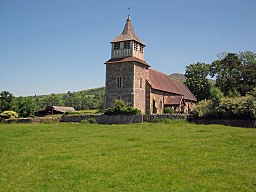
(c) Trevor Rickard, CC BY-SA 2.0 St Mary's Church i Bitterley. | |
| Land | |
|---|---|
| Riksdel | England |
| Region | West Midlands |
| Ceremoniellt grevskap | Shropshire |
| Enhetskommun | Shropshire |
| Civil parish | Bitterley |
| Koordinater | 52°23′35″N 2°38′39″V / 52.3930°N 2.6441°V |
| Folkmängd | 802 (2001) |
| Tidszon | GMT (UTC+0) |
| Postort | LUDLOW |
| Riktnummer | 01584 |
| Geonames | 2655539 7292252 |
Bitterley är en by och civil parish i Shropshire i England. Orten omnämns som Buterlei i Domesday Book. Bykyrkan härstammar från 1100-talet.
Källor
- Den här artikeln är helt eller delvis baserad på material från engelskspråkiga Wikipedia, tidigare version.
Media som används på denna webbplats
Författare/Upphovsman: Alexrk2, Licens: CC BY-SA 3.0
Location map of the United Kingdom
Shiny red button/marker widget. Used to mark the location of something such as a tourist attraction.
(c) Trevor Rickard, CC BY-SA 2.0
St Mary's parish church, Bitterley, Shropshire, seen from the west. The summit of Titterstone Clee Hill is can be seen above the chancel roof.


