Bimini
| Bimini District (Bimini) | |
| Biminis | |
| Distrikt | |
| Land | |
|---|---|
| Höjdläge | 7 m ö.h. |
| Koordinater | 25°42′16″N 79°17′20″V / 25.70444°N 79.28889°V |
| Folkmängd | 2 417 (2022)[1] |
| Tidszon | EST (UTC-5) |
| - sommartid | EDT (UTC-4) |
| Geonames | 3572807 |
Biminidistriktet | |

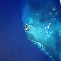
Bimini är ett distrikt i Bahamas som består av en samling öar, omkring 81 km öster om Miami, Florida. Bimini-öarna är den del av Bahamas som ligger närmast USA:s fastland. Öar i distriktet är bland annat Cat Cays, Cay Sal, Elbow Cays, Gun Cay, North Cat Cay, Ocean Cay och South Bimini. Alice Town på North Bimini är administrativt centrum som även är den ön flest turister besöker följt av South Bimini och North Cat Cay.
USA:s inrikespolitik har påverkat befolkningsutvecklingen. Amerikanska inbördeskriget 1861–65 innebar att Bimini blev ett smugglingscentrum för sydstaterna. Efter kriget minskade befolkningen i takt med att navigationsmöjligheterna för sjöfarten förbättrades, vilket innebar att Biminis huvudnäring skeppsbärgning och vrakplundring minskade.
Befolkningsnedgången fortsatte och minskade fram till förbudstiden 1920–33, då ekonomin åter tog fart och Bimini återigen förvandlades till ett smugglingscentrum. Efter andra världskriget har befolkningen stigit på grund av den ökade turismen. Biminis närhet till Miami har nu för tredje gången gjort öarna till ett smugglingsnäste. Denna gång droger ifrån Karibien och Latinamerika. Befolkningen uppgår nu till 2417 (2022).
Bimini är internationellt känt för djuphavsfiske med återkommande tävlingar.
Historisk befolkningsutveckling
| År | Befolkning |
| 1835 | 14 |
| 1851 | 150 |
| 1861 | 210 |
| 1871 | 746 |
| 1881 | 663 |
| 1891 | 566 |
| 1901 | 545 |
| 1911 | 505 |
| 1921 | 638 |
| 1931 | 756 |
| 1943 | 725 |
| 1953 | 1330 |
| 1963 | 1658 |
| 1970 | 1503 |
| 1980 | 1411 |
| 1990 | 1639 |
| 2000 | 1717 |
| 2022 | 2417 |
Referenser
Källor
- History of the Bahamas: Bimini : a Case Study, Volym 2 s.14 av Ashley B. Saunders.
- Islanders in the Stream: A History of the Bahamian People Vol 2 s.59 av Michael Craton,Gail Saunders.
- http://statistics.bahamas.gov.bs
Noter
- ^ ”2022 CENSUS OF POPULATION AND HOUSING”. Bahamas National Statistical Institute. https://www.bahamas.gov.bs/wps/wcm/connect/c0d9fae8-54df-49e3-b4b9-92e29e0b264c/2022+CENSUS+PRELIMINARY+RESULTS_FINAL+April+12+2023.pdf?MOD=AJPERES. Läst 25 februari 2024.
Vidare läsning
- Curran, A., and B. White, eds., 2005, Terrestrial and shallow marine geology of the Bahamas and Bermuda. Special Paper no. 300. Geological Society of America, Boulder, Colorado. ISBN 0-8137-2300-0
- Jennings, D., Gruber, S. H., Franks, B., Kessel, S. & Robertson, A. (2008). Effects of large-scale anthropogenic development on juvenile lemon shark (Negaprion brevirostris) populations of Bimini, Bahamas. Environmental Biology of Fishes 83, 369-377. DOI 10.1007/s10641-008-9357-3 Sprinterlink - Environmental Biology of Fishes
- Kresge, Dave, 2005, VantagePoint Guide to Bimini, VantagePoint Guides. ISBN 0-9729589-1-6
- Saunders, Ashley, 2000, History of Bimini, Volume I, New World Press.
- Shinn, E. A., 2009, The mystique of beachrock. in Perspectives in Carbonate Geology: A Tribute to the Career of Robert Nathan Ginsburg, P. K. Swart, G. Eberli, and J. A. McKenzie, eds., pp. 19-28. Special Publication no. 41. International Association of Sedimentologists. ISBN 978-1-4051-9380-1
- Zink, David, 1978, 'The Stones of Atlantis, Prentice Hall Trade. ISBN 0-13-846923-7
Externa länkar
- Bimini Police Royal Bahamas Police
- Bimini Biological Field Station
- Save Bimini Association
- Bimini Kiteboarding / SUP
- Bimini Island Air
|
Media som används på denna webbplats
Shiny red button/marker widget. Used to mark the location of something such as a tourist attraction.
Bimini Island, Bahama Islands - June 1998
- The westernmost and closest to the United States mainland, the island of Bimini can be seen in this south-southwest-looking view. The two small islands that make up Bimini cover a total area of 9 sq. miles (23 sq. km). The waters surrounding Bimini are known for their excellent fishing. Bimini resembles an idyllic South Pacific atoll with a blue lagoon nearly enclosed by the two small islands. The island was named for the mythical island of Bimini, supposed site of the "Fountain of Youth", the quest for which led to the discovery of Florida in 1513 by Ponce De Leon.
Författare/Upphovsman:
- Bahamas_location_map.svg: NordNordWest
- derivative work: ~~Uniongreen113~~
Location map of the Bahamas
Författare/Upphovsman: Nzeemin, Licens: CC BY-SA 3.0
Relief map of the Bahamas


