Biharkeresztes
| Biharkeresztes | |||
| Kommun | |||
Centrum i Biharkeresztes | |||
| |||
| Land | |||
|---|---|---|---|
| Region | Norra Slättlandet | ||
| Provins | Hajdú-Bihar | ||
| Distrikt | Berettyóújfalu | ||
| Höjdläge | 97 m ö.h. | ||
| Koordinater | 47°7′30″N 21°43′5″Ö / 47.12500°N 21.71806°Ö | ||
| Area | 49,26 km² (2024-01-01)[1] | ||
| Folkmängd | 3 853 (2024-01-01)[1] | ||
| Befolkningstäthet | 78 invånare/km² | ||
| Tidszon | CET (UTC+1) | ||
| - sommartid | CEST (UTC+2) | ||
| Postnummer | 4110 | ||
| Riktnummer | 54 | ||
| KSH-kod | 19956 | ||
| Geonames | 722281 | ||
| OSM-karta | 1444159 | ||
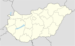
Läge i Ungern | |||
| Webbplats: www.biharkeresztes.asp.lgov.hu | |||
Biharkeresztes är en stad och kommun i distriktet Berettyóújfalu i provinsen Hajdú-Bihar i östra Ungern. Den ligger vid gränsen till Rumänien. Kommunen har 3 853 invånare (2024), på en yta av 49,26 km².[1]
Referenser
- ^ [a b c] ”Localities 01.01.2024.”. Detailed Gazetteer of Hungary. Központi Statisztikai Hivatal (KSH). https://www.ksh.hu/docs/helysegnevtar/dgh_download_2024.xlsx. Läst 25 januari 2025.
Externa länkar
 Wikimedia Commons har media som rör Biharkeresztes.
- Officiell webbplats
| |||||||
Media som används på denna webbplats
Shiny red button/marker widget. Used to mark the location of something such as a tourist attraction.
Författare/Upphovsman: Mieresch, Licens: CC0
A view of downtown Biharkeresztes, Hungary, with the Catholic and Calvinist churches.
Författare/Upphovsman: NordNordWest (diskussion · bidrag), Licens: CC BY-SA 3.0
Location map of Hungary
The coat of arms of Biharkeresztes


