Big Rapids
| Big Rapids | |
| Stad (city) | |
| Land | |
|---|---|
| Delstat | |
| County | Mecosta County |
| Höjdläge | 282 m ö.h. |
| Koordinater | 43°41′56″N 85°28′52″V / 43.69889°N 85.48111°V |
| Area | 11,62 km² (2010)[2] |
| Folkmängd | 7 727 (2020)[3] |
| Befolkningstäthet | 665 invånare/km² |
| Grundad | 1855[1] |
| Tidszon | EST (UTC-5) |
| - sommartid | EDT (UTC-4) |
| ZIP-kod | 49307 |
| Riktnummer | 231 |
| GNIS-kod | 1619197 |
| Geonames | 4986020 |
Översiktskarta | |
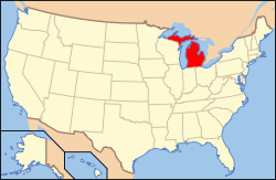
Michigans läge i USA | |
| Wikimedia Commons: Big Rapids, Michigan | |
| Webbplats: http://www.ci.big-rapids.mi.us/ | |
| Redigera Wikidata | |
Big Rapids är en stad i Mecosta County i delstaten Michigan, USA. Vid folkräkningen år 2010 var folkmängden 10 601. Big Rapids är administrativ huvudort (county seat) i Mecosta County.
Staden är belägen centralt i den södra delen av Michigan, den så kallade "nedre halvön". Närmaste större stad är Grand Rapids. Genom staden går floden Muskegon.
I staden ligger Ferris State University, ett universitet som 2005 hade 12 547 inskrivna studenter. Staden har även ett sjukhus som är huvudsjukhus för Mecosta County.
Referenser
- ^ härlett från: Kategori:Orter grundade 1855, läst: 7 november 2018.[källa från Wikidata]
- ^ United States Census Bureau, 2010 U.S. Gazetteer Files, United States Census Bureau, 2010, läst: 9 juli 2020.[källa från Wikidata]
- ^ United States Census Bureau (red.), USA:s folkräkning 2020, läs online, läst: 1 januari 2022.[källa från Wikidata]
Media som används på denna webbplats
Författare/Upphovsman:
| This media | uploader |
|---|---|
| Original work | en:User:Wapcaplet |
Map of USA with Michigan highlighted
Författare/Upphovsman: Arkyan, Licens: CC BY-SA 3.0
This map shows the incorporated and unincorporated areas in Mecosta County, Michigan, highlighting Big Rapids in red. It was created with a custom script with US Census Bureau data and modified with Inkscape.
The Nisbett Building in Big Rapids, Michigan, circa 1906. It is a Michigan State Historic Site and is listed on the NRHP.


