Bethel Park
| Bethel Park | |
| borough | |
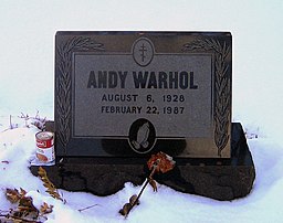
Andy Warhols grav. | |
| Land | |
|---|---|
| Delstat | Pennsylvania |
| County | Allegheny County |
| Höjdläge | 365 m ö.h. |
| Koordinater | 40°19′39″N 80°2′22″V / 40.32750°N 80.03944°V |
| Yta | 30 km² (2010) |
| - land | 30 km² |
| - vatten | 0 km² |
| Folkmängd | 33 577 (2020) |
| Befolkningstäthet | 1 119 invånare/km² |
| Tidszon | EST (UTC-5) |
| - sommartid | EDT (UTC-4) |
| ZIP-kod | 15102, 15234, 15236, 15241 |
| Riktnummer | 412 |
| FIPS | 4206064 |
| Geonames | 5180199 |
Ortens läge i Pennsylvania | |
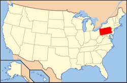
Pennsylvanias läge i USA | |
| Webbplats: bethelpark.net | |
Bethel Park är en kommun i Allegheny County i Pennsylvania.[1] Vid 2020 års folkräkning hade Bethel Park 33 577 invånare.[2]
Källor
- ^ Bethel Park, PA. Map Quest. Läst 14 maj 2020.
- ^ ”2020 Decennial Census” (på engelska). United States Census Bureau. https://data.census.gov/cedsci/profile?g=1600000US4206064. Läst 4 juni 2022.
| ||||||||||
|
Media som används på denna webbplats
Shiny red button/marker widget. Used to mark the location of something such as a tourist attraction.
Författare/Upphovsman: Huebi, Licens: CC BY 2.0
Map of USA with Pennsylvania highlighted
Chad Snoke, Andy Warhol tombstone, St. John the Baptist Byzantine Catholic Cemetery, Bethel Park, PA, March 18, 2007. The can with a food product from company Campbell's is not somebody's tasteless joke, but to honour one of Warhol's most famous series of pieces of art, which included the graphical depiction of various products from Campbell's.
Författare/Upphovsman: Alexrk2, Licens: CC BY 3.0
Location map of Pennsylvania, USA


