Bernie
| Bernie | |
| Stad (city) | |
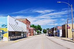
Huvudgatan i Bernie | |
| Land | |
|---|---|
| Delstat | |
| County | Stoddard County |
| Höjdläge | 92 m ö.h. |
| Koordinater | 36°40′15″N 89°58′10″V / 36.67083°N 89.96944°V |
| Area | 3,39 km² (2020)[1] |
| Folkmängd | 1 859 (2020)[2][3] |
| Befolkningstäthet | 549 invånare/km² |
| Grundad | 1890 |
| Tidszon | CST (UTC-6) |
| - sommartid | CDT (UTC-5) |
| ZIP-kod | 63822 |
| Riktnummer | 573 |
| GNIS-kod | 713988 |
| Geonames | 4376632 |
Bernie i Stoddard County och Missouri | |
Missouris läge i USA | |
| Wikimedia Commons: Bernie, Missouri | |
| Redigera Wikidata | |
Bernie är en ort (city) i Stoddard County i delstaten Missouri i USA. Orten hade 1 859 invånare, på en yta av 3,39 km² (2020).[4][5]
Referenser
- ^ Gazetteer Files – 2020 (på engelska), United States Census Bureau, läs online, läst: 22 december 2021.[källa från Wikidata]
- ^ Explore Census Data – Bernie city, Missouri (på engelska), United States Census Bureau, läs online, läst: 22 december 2021.[källa från Wikidata]
- ^ United States Census Bureau (red.), USA:s folkräkning 2020, läs online, läst: 1 januari 2022.[källa från Wikidata]
- ^ ”Explore Census Data – Bernie city, Missouri” (på engelska). United States Census Bureau. https://data.census.gov/cedsci/profile?g=1600000US2904960. Läst 22 december 2021.
- ^ ”Gazetteer Files – 2020” (på engelska). United States Census Bureau. https://www.census.gov/geographies/reference-files/time-series/geo/gazetteer-files.2020.html. Läst 22 december 2021.
Externa länkar
 Wikimedia Commons har media som rör Bernie.
Media som används på denna webbplats
Författare/Upphovsman: Brian Stansberry, Licens: CC BY 4.0
Main Street (Missouri Route Z / Stoddard Co.) in Bernie, Missouri, United States
Författare/Upphovsman: Arkyan, Licens: CC BY-SA 3.0
This map shows the incorporated and unincorporated areas in Stoddard County, Missouri, highlighting Bernie in red. It was created with a custom script with US Census Bureau data and modified with Inkscape.
Författare/Upphovsman: This version: uploader
Base versions this one is derived from: originally created by en:User:Wapcaplet, Licens: CC BY 2.0
Map of USA with Missouri highlighted


