Belper
| Belper | |
Joseph Street | |
| Land | |
|---|---|
| Riksdel | England |
| Region | East Midlands |
| Ceremoniellt grevskap | Derbyshire |
| Administrativt grevskap | Derbyshire |
| Distrikt | Amber Valley |
| Koordinater | 53°01′23″N 1°29′05″V / 53.0231°N 1.4846°V |
| Tidszon | GMT (UTC+0) |
| Postnummerområde | DE56 |
| Riktnummer | 01773 |
| Geonames | 2655942 7294954 |
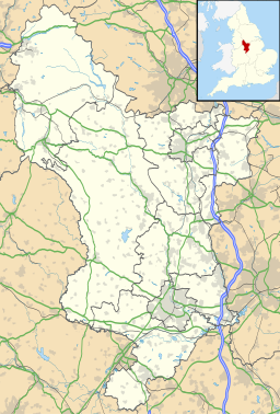
Contains Ordnance Survey data © Crown copyright and database right, CC BY-SA 3.0 Belpers läge i Derbyshire | |
Belper är en stad och en civil parish i Amber Valley, Derbyshire, England. Orten har 20 548 invånare (2001).[1]
Referenser
- ^ ”Neighbourhood statistics”. Arkiverad från originalet den 4 mars 2016. https://web.archive.org/web/20160304220838/http://www.neighbourhood.statistics.gov.uk/dissemination/LeadTableView.do?a=3&b=793218&c=Belper&d=16&e=15&g=433168&i=1001x1003x1004&o=1&m=0&r=1&s=1327603468268&enc=1&dsFamilyId=779. Läst 26 januari 2012.
Externa länkar
Media som används på denna webbplats
Shiny red button/marker widget. Used to mark the location of something such as a tourist attraction.
Belper: Nailer's workshop in Joseph Street
Contains Ordnance Survey data © Crown copyright and database right, CC BY-SA 3.0
Map of Derbyshire, UK with the following information shown:
- Administrative borders
- Coastline, lakes and rivers
- Roads and railway station are
- Urban areas
Equirectangular map projection on WGS 84 datum, with N/S stretched 165%
Geographic limitation :
- West: 2.06W
- East: 1.10W
- North: 53.55N
- South: 52.69N


