Bayeux
- För andra betydelser, se Bayeux (olika betydelser).
| Bayeux | ||
| Kommun | ||
 Gamla stan | ||
| ||
| Land | ||
|---|---|---|
| Region | ||
| Departement | ||
| Arrondissement | Bayeux | |
| Kanton | Bayeux | |
| Koordinater | 49°16′N 0°42′V / 49.267°N 0.700°V | |
| Yta | 7,1 km²[1] | |
| Folkmängd | 12 775 ()[2] | |
| Befolkningstäthet | 1 799 invånare/km² | |
| Tidszon | CET (UTC+1) | |
| - sommartid | CEST (UTC+2) | |
| Postnummer | 14400 | |
| INSEE | 14047 | |
| Geonames | 3034483 | |
| OSM-karta | 145776 | |
 Kommunens läge i regionen Normandie i Frankrike | ||
| Webbplats: https://bayeux.fr | ||


Bayeux är en kommun i departementet Calvados i Normandie i regionen Normandie i norra Frankrike. Kommunen ligger i kantonen Bayeux som ligger i arrondissementet Bayeux. År 2021 hade Bayeux 12 775 invånare. Bayeux är beläget cirka 10 kilometer från kusten rakt söder om Arromanches och är en av de första franska städer som befriades av de allierade styrkorna i samband med Operation Overlord.
Staden är känd för den drygt 70 meter långa och cirka 50 cm breda Bayeuxtapeten. Den innehåller 72 scener, som beskriver Vilhelm Erövrarens fälttåg mot England och slaget vid Hastings 1066. Ursprunget har alltid varit omdiskuterat, men den anses ha tillkommit i slutet av 1000-talet. Den förvaras nu bakom glas i Musée de la Tapisserie de Bayeux i Bayeux.
Befolkningsutveckling
Antalet invånare i kommunen Bayeux
Referens: INSEE[3]
Galleri
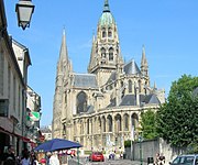 Katedralen
 Nya stan
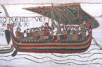
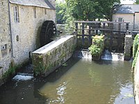 Den gamla kvarnen
 Stridsvagn från invasionen i Normandie
Källor
- ^ Répertoire géographique des communes, Institut national de l'information géographique et forestière, läst: 26 oktober 2015, licens: öppen licens.[källa från Wikidata]
- ^ Populations légales 2021, Institut National de la Statistique et des Études Économiques, 28 december 2023.[källa från Wikidata]
- ^ Chiffres clés - Évolution et structure de la population Arkiverad 5 juli 2012 hämtat från the Wayback Machine.
 Wikimedia Commons har media som rör Bayeux.
Media som används på denna webbplats

Författare/Upphovsman: Eric Gaba (Sting - fr:Sting), Licens: CC BY-SA 4.0
Blank physical map of metropolitan France for geo-location purpose.
Scale : 1:14 816 000 (accuracy : about 3,7 km) for the bathymetry. More maps of France, view → Commons Atlas of France.

Shiny red button/marker widget. Used to mark the location of something such as a tourist attraction.

Catedral de Bayeux
Författare/Upphovsman:
|
Map data (c) OpenStreetMap contributors, CC-BY-SA _French_municipality_map.svg) • Shape files infrastructure: railway, highways, water: all originally by OpenStreetMap contributors. Status december 2011 *note: shown commune boundaries are from OSM dump May 2012; at that time about 90% complete |
Map commune FR insee code 14047.png

.svg)
Författare/Upphovsman: Den här vektorbilden skapades med Inkscape av v ., Licens: CC BY-SA 3.0
Gules, two lions passant guardant in pale or armed and langued azure, used as the inofficial "coat of arms of Normandy".
Coat of arms attributed to "Arms of William the Conqueror (William I of England)"

Författare/Upphovsman: Mark from Woking, United Kingdom, Licens: CC BY 2.0
Functioning water mill.
Bayeux
Författare/Upphovsman: Anton Bielousov, Licens: CC BY-SA 3.0
Bayeux historic centre: office of tourism and Bayeux cathedral

Författare/Upphovsman: Anton Bielousov, Licens: CC BY-SA 3.0
Center of Bayeux town on week-end (Normandy, France)
