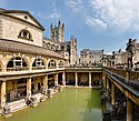
Bath and North East Somerset
| Bath and North East Somerset | |
| Enhetskommun | |
| Land | Storbritannien |
|---|---|
| Riksdel | England |
| Region | Sydvästra England |
| Ceremoniellt grevskap | Somerset |
| Koordinater | 51°20′N 2°30′V / 51.33°N 2.5°V |
| HUvudorter | Bath och Keynsham |
| Area | 346 km²[1] |
| Folkmängd | 195 618 (2022)[2] |
| Befolkningstäthet | 565 invånare/km² |
| Grundad | 1 april 1996 |
| Tidszon | UTC (UTC+0) |
| - sommartid | BST (UTC+1) |
| ISO 3166-2-kod | GB-BAS |
| GSS-kod | E06000022 |
| Geonames | 3333123 |
Contains Ordnance Survey data © Crown copyright and database right, CC BY-SA 3.0 Läge i Somerset | |
Bath and North East Somerset är en enhetskommun (unitary authority) i det ceremoniella grevskapet Somerset i sydvästra England i Storbritannien. Kommunen har 195 618 invånare (2022)[2]. Den skapades 1 april 1996 genom sammanslagning av staden Bath och distriktet Wansdyke, samtidigt som grevskapet Avon, som området tidigare hade tillhört, upplöstes. Bath är den viktigaste orten i distriktet, men det omfattar också Keynsham, Midsomer Norton, Radstock och Chew Valley. Ungefär hälften av invånarna bor i Bath, vilket gör staden 12 gånger mer tätbefolkad än resten av området. Distriktet gränsar till Somerset (inklusive North Somerset), Bristol, South Gloucestershire och Wiltshire.
Administrativ indelning
Bath and North East Somerset utanför staden Bath delas in i 49 civil parishes:
- Bathampton
- Batheaston
- Bathford
- Camerton
- Charlcombe
- Chelwood
- Chew Magna
- Chew Stoke
- Claverton
- Clutton
- Combe Hay
- Compton Dando
- Compton Martin
- Corston
- Dunkerton and Tunley
- East Harptree
- Englishcombe
- Farmborough
- Farrington Gurney
- Freshford
- High Littleton
- Hinton Blewett
- Hinton Charterhouse
- Kelston
- Keynsham (town)
- Marksbury
- Midsomer Norton (town)
- Monkton Combe
- Nempnett Thrubwell
- Newton St. Loe
- Norton Malreward
- Paulton
- Peasedown St John
- Priston
- Publow with Pensford
- Radstock (town)
- Saltford
- Shoscombe
- Southstoke
- Stanton Drew
- Stowey-Sutton
- Swainswick
- Temple Cloud with Cameley
- Timsbury
- Ubley
- Wellow
- Westfield
- West Harptree
- Whitchurch
Klimat
Kustklimat råder i trakten.[3] I Bath finns en väderstation. Där är den varmaste månaden är juli och den kallaste är januari.
| Bath | ||||||||||||||||||||||||||||||||||||||||||||||||||||||||||||
|---|---|---|---|---|---|---|---|---|---|---|---|---|---|---|---|---|---|---|---|---|---|---|---|---|---|---|---|---|---|---|---|---|---|---|---|---|---|---|---|---|---|---|---|---|---|---|---|---|---|---|---|---|---|---|---|---|---|---|---|---|
| Klimatdiagram (förklaring) | ||||||||||||||||||||||||||||||||||||||||||||||||||||||||||||
| ||||||||||||||||||||||||||||||||||||||||||||||||||||||||||||
Källor
- Den här artikeln är helt eller delvis baserad på material från en annan språkversion av Wikipedia.
- ^ ”Estimates of the population for the UK, England, Wales, Scotland, and Northern Ireland (Mid-2022)” (på engelska) (xls). Landyta, avrundad till hela km². Office for National Statistics. 26 mars 2024. https://www.ons.gov.uk/peoplepopulationandcommunity/populationandmigration/populationestimates/datasets/populationestimatesforukenglandandwalesscotlandandnorthernireland. Läst 25 juni 2024.
- ^ [a b] ”Estimates of the population for the UK, England, Wales, Scotland, and Northern Ireland (Mid-2022)” (på engelska) (xls). Office for National Statistics. 26 mars 2024. https://www.ons.gov.uk/peoplepopulationandcommunity/populationandmigration/populationestimates/datasets/populationestimatesforukenglandandwalesscotlandandnorthernireland. Läst 25 juni 2024.
- ^ Peel, M C; Finlayson, B L; McMahon, T A (2007). ”Updated world map of the Köppen-Geiger climate classification”. Hydrology and Earth System Sciences 11: sid. 1633-1644. doi:. http://www.hydrol-earth-syst-sci.net/11/1633/2007/hess-11-1633-2007.html. Läst 30 januari 2016.
- ^ Bath climate information, Met Office.
Externa länkar
- Bath and North East Somerset Council
 Wikimedia Commons har media som rör Bath and North East Somerset.
Media som används på denna webbplats
Contains Ordnance Survey data © Crown copyright and database right, CC BY-SA 3.0
Map of Somerset, UK with Bath and North East Somerset highlighted.
Equirectangular map projection on WGS 84 datum, with N/S stretched 155%Författare/Upphovsman: Diliff, Licens: CC BY 2.5
The Roman Baths (Thermae) of Bath, England. This is a 6 segment panorama taken by myself with a Canon 5D and 24-105mm f/4L IS lens.


