Bath, New York
| Bath | |
| Bykommun | |
Historiskt distrikt på Liberty Street. | |
| Land | |
|---|---|
| Delstat | |
| County | Steuben County |
| Höjdläge | 338 m ö.h. |
| Koordinater | 42°20′16″N 77°19′1″V / 42.33778°N 77.31694°V |
| Area | 8,22 km² (2010)[2] |
| Folkmängd | 5 571 (2020)[3] |
| Befolkningstäthet | 677 invånare/km² |
| Grundad | 1793[1] |
| Tidszon | EST (UTC-5) |
| - sommartid | EDT (UTC-4) |
| ZIP-kod | 14810 |
| GNIS-kod | 943162 |
| Geonames | 5108110 |
(c) NordNordWest, CC BY 3.0 Ortens läge i delstaten | |
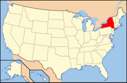
New Yorks läge i USA | |
| Wikimedia Commons: Bath (village), New York | |
| Redigera Wikidata | |
Bath är en ort i den amerikanska delstaten New York med en yta av 7,5 km² och en folkmängd, som uppgår till 5 641 invånare (2000). Bath är administrativ huvudort (county seat) i Steuben County. Orten grundades 1793.
Referenser
- ^ härlett från: Kategori:Orter grundade 1793, läst: 7 november 2018.[källa från Wikidata]
- ^ United States Census Bureau, 2010 U.S. Gazetteer Files, United States Census Bureau, 2010, läst: 9 juli 2020.[källa från Wikidata]
- ^ United States Census Bureau (red.), USA:s folkräkning 2020, läs online, läst: 1 januari 2022.[källa från Wikidata]
Externa länkar
 Wikimedia Commons har media som rör Bath, New York.
- Bath, New York
Media som används på denna webbplats
Shiny red button/marker widget. Used to mark the location of something such as a tourist attraction.
Författare/Upphovsman: Huebi, Licens: CC BY 2.0
Map of USA with New York highlighted
(c) NordNordWest, CC BY 3.0
Location map of the State of New York, USA
Liberty Street Historic District, Bath, NY, October 2009


