Barnard Castle (ort)
| Barnard Castle | |
| Ort | |
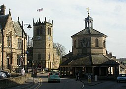
(c) Ben Gamble, CC BY-SA 2.0 Centrala Barnard Castle | |
| Land | |
|---|---|
| Riksdel | England |
| Region | Nordöstra England |
| Enhetskommun | Durham |
| Ceremoniellt grevskap | Durham |
| Koordinater | 54°32′41″N 01°55′29″V / 54.54472°N 1.92472°V |
| Area | 2,32 km²[1] |
| Folkmängd | 7 040 (2011)[1] |
| Befolkningstäthet | 3 034 invånare/km² |
| Tidszon | WET (UTC+0) |
| - sommartid | BST (UTC+1) |
| Postort | BARNARD CASTLE |
| Postnummer | DL12 |
| Riktnummer | 01833 |
| Geonames | 2656305 |
Contains Ordnance Survey data © Crown copyright and database right, CC BY-SA 3.0 Barnard Castles läge i Durham | |
| Webbplats: www.barnardcastletowncouncil.gov.uk | |
Barnard Castle är en ort och civil parish i grevskapet Durham i England. Orten ligger i kommunen Durham i Teesdale, cirka 24 kilometer väster om Darlington och cirka 34 kilometer sydväst om Durham. Den ligger vid floden Tees. Tätorten (built-up area) hade 7 040 invånare vid folkräkningen år 2011.[1] Orten är uppkallad efter slottet Barnard Castle.
Referenser
- ^ [a b c] ”Barnard Castle Built-up area - Local Area Report - Nomis”. www.nomisweb.co.uk. https://www.nomisweb.co.uk/reports/localarea?compare=E34004224. Läst 18 juni 2020.
Externa länkar
 Wikimedia Commons har media som rör Barnard Castle (ort).
Media som används på denna webbplats
Shiny red button/marker widget. Used to mark the location of something such as a tourist attraction.
(c) Ben Gamble, CC BY-SA 2.0
The centre of Barnard Castle, County Durham. Centre right is the butter market. On the left is part of Barclay's Bank. Between them is the west tower of St Mary's parish church.
Contains Ordnance Survey data © Crown copyright and database right, CC BY-SA 3.0
Map of County Durham, UK with the following information shown:
- Administrative borders
- Coastline, lakes and rivers
- Roads and railways
- Urban areas
Equirectangular map projection on WGS 84 datum, with N/S stretched 170%
Geographic limits:
- West: 2.40W
- East: 1.05W
- North: 54.95N
- South: 54.43N


