Bard, Aostadalen
| Bard | ||
| Kommun | ||
| ||
| Officiellt namn: Comune di Bard (it Commune de Bard (fr) | ||
| Land | ||
|---|---|---|
| Region | Aostadalen | |
| Höjdläge | 400 m ö.h. | |
| Koordinater | 45°36′34″N 7°44′42″Ö / 45.60936°N 7.74491°Ö | |
| Yta | 3,03 km²[1] | |
| Folkmängd | 113 (2017)[2] | |
| Befolkningstäthet | 37 invånare/km² | |
| Tidszon | CET (UTC+1) | |
| - sommartid | CEST (UTC+2) | |
| Postnummer | 11020 | |
| Riktnummer | 0125 | |
| ISTAT-kod | 007009 | |
| Geonames | 6540316 | |
| Skyddspatron | Jungfru Marie himmelsfärd | |
Kommunens läge i Italien | ||
Kommunens läge i Aostadalen | ||
| Webbplats: http://www.comune.bard.ao.it/ | ||
Bard är en ort och kommun i regionen Aostadalen i nordvästra Italien. Kommunen hade 113 invånare (2017)[2] och har italienska och franska som officiella språk.
Referenser
- ^ ”Geomorphological characteristics of municipalities”. 2017. Arkiverad från originalet den 16 maj 2019. https://web.archive.org/web/20190516211155/http://dati.istat.it//Index.aspx?QueryId=34711. Läst 7 juli 2019.
- ^ [a b] ”Statistiche demografiche ISTAT”. demo.istat.it. Arkiverad från originalet den 16 juli 2018. https://web.archive.org/web/20180716065929/http://demo.istat.it/bilmens2017gen/index.html. Läst 7 juli 2019.
| |||||||
|
Media som används på denna webbplats
Författare/Upphovsman: Eric Gaba (Sting - fr:Sting) and NordNordWest, Licens: CC BY-SA 3.0
Blank physical map of Italy including the 08-2009 modification of the boundary between Emilia-Romagna and Marche regions, for geo-location purpose.
Shiny red button/marker widget. Used to mark the location of something such as a tourist attraction.
Map of the municipality (comune) of Bard (region Aosta Valley, Italien)
Författare/Upphovsman: Ingen maskinläsbar skapare angavs. Ssire antaget (baserat på upphovsrättsanspråk)., Licens: CC BY-SA 3.0
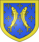
Blasonnement
- D'azur semé de croisettes potencées au pied fiché, à deux bars adossés brochant et à la bordure, tous d'or.
- "D’azzurro seminato di crocette potenziate, fitte in punta, a due barbi addossati in palo sul tutto e alla bordura, il tutto d’oro. Ornamenti esteriori da Comune. Nastro partito con i colori dello Stato e della Regione"
- El azuro semita de krucetoj, to-izita, piede pintigita, kun du barbfiŝoj dors-al-dorse surmetitaj, kaj kun randajxo, ĉiuj el oro.
Map of the Provincia of Aosta.
Författare/Upphovsman: Patafisik, Licens: CC BY-SA 3.0
Panorama sul borgo medievale di Bard, dominato dal forte di Bard. Dietro al forte, nascosto alla vista, il resto del borgo. In basso nella foto, dall'altra parte del fiume, si trova Hône. Valle d'Aosta, Italia.


