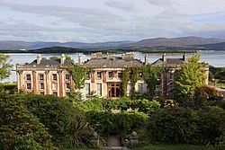
Bantry
| Bantry | ||
| Beanntraí | ||
| Ort | ||
Vy över Bantry | ||
| ||
| Land | ||
|---|---|---|
| Provins | Munster | |
| Grevskap | Cork | |
| Koordinater | 51°40′47″N 9°27′9″V / 51.67972°N 9.45250°V | |
| Folkmängd | 2 722 (2016)[1] | |
| Tidszon | WET (UTC±0) | |
| - sommartid | WEST (UTC+1) | |
| Geonames | 2966356 | |
(c) Karte: NordNordWest, Lizenz: Creative Commons by-sa-3.0 de Läge i Irland | ||
| Webbplats: www.bantry.ie | ||


Bantry (iriska: Beanntraí) är en kustort i grevskapet Cork på Irland. Den är belägen längs med vägen N71 vid Bantry Bay. Bearahalvön ligger nordväst om Bantry och halvön Muntervary ligger även den nära orten. Bantry är ett viktigt ekonomiskt centrum för regionen. Förutom turism är fiske en av huvudindustrierna. Strax utanför Bantry ligger herrgården Bantry House.
Tätorten (settlement) Bantry hade 2 722 invånare vid folkräkningen 2016.[1]
Referenser
- ^ [a b] ”Central Statistics Office - Census 2016 Small Area Population Statistics”. cso.maps.arcgis.com. Central Statistics Office (CSO). https://cso.maps.arcgis.com/apps/webappviewer/index.html?id=4d19cf7b1251408c99ccde18859ff739. Läst 11 augusti 2022.
Externa länkar
 Wikimedia Commons har media som rör Bantry.
Media som används på denna webbplats
Shiny red button/marker widget. Used to mark the location of something such as a tourist attraction.
Författare/Upphovsman: Dzjamkokarlis, Licens: CC BY-SA 4.0
Bantry from above, The Wild Atlantic View
Författare/Upphovsman: Jörg Bittner Unna, Licens: CC BY-SA 4.0
Bantry House constructed in about 1700 on the South side of Bantry Bay
Wolfe Tone Square im Stadtzentrum
(c) Karte: NordNordWest, Lizenz: Creative Commons by-sa-3.0 de
Location map of Ireland
Författare/Upphovsman: CeltBrowne, Licens: CC BY-SA 4.0
The Coat of Arms of the town of Bantry, County Cork, Ireland as per the offical blazon: Azure, on a bend sinister argent between in chief an ancient stone passion cross or and in base a boar passant proper three antique ships sable, with the Motto: Ná cluinter claoi claoitecht oraibh ("Never may defeat be told of you")


