Balzers
| Balzers | |||
| Ort Kommun | |||
Balzers | |||
| |||
| Land | |||
|---|---|---|---|
| Valkrets | Oberland | ||
| Höjdläge | 477 m ö.h. | ||
| Koordinater | 47°04′00″N 09°30′00″Ö / 47.06667°N 9.50000°Ö | ||
| Area | 19,731 km² | ||
| Folkmängd | 4 595 (2017-06-30)[1] | ||
| Befolkningstäthet | 233 invånare/km² | ||
| Tidszon | CET (UTC+1) | ||
| - sommartid | CEST (UTC+2) | ||
| Postnummer | 9496 | ||
| Kommunkod | 7003 | ||
| Geonames | 3042074 | ||
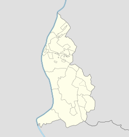
Orten Balzers läge i Liechtenstein | |||
Kommunen Balzers i Liechtenstein | |||
| Webbplats: www.balzers.li | |||
Balzers är en ort och kommun i södra Liechtenstein. Kommunen hade 4 595 invånare (2017).[1]
Huvuddelen av kommunen ligger längs Rhen, men kommunen har även två exklaver i andra delar av Liechenstein. I kommunen ligger, förutom kommunhuvudorten Balzers, även orten Mäls.
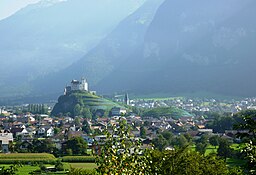
I kommunen ligger medeltidsborgen Burg Gutenberg.
Referenser
- ^ [a b] ”Bevölkerungsstatistik 30. Juni 2017” (på tyska) (PDF). Amt für Statistik (AS). sid. 7. https://www.llv.li/files/as/bevolkerungsstatistik-30-juni-2017.pdf. Läst 18 juni 2018.
Externa länkar
 Wikimedia Commons har media som rör Balzers.
- Officiell webbplats
| |||||||
Media som används på denna webbplats
Flag of Liechtenstein
Shiny red button/marker widget. Used to mark the location of something such as a tourist attraction.
Författare/Upphovsman: unknown, Licens:
Författare/Upphovsman: St9191, Licens: CC BY-SA 3.0
View to the castle Gutenberg in Balzers, Liechtenstein (parts of a power line retouched).
Flag of Balzers municipality, Liechtenstein (simple striped version)
Författare/Upphovsman: TUBS
Location of municipality Balzers in Liechtenstein in Liechtenstein


