Bakerloo Line
| London Underground Bakerloo Line | |
 Oxford Circus. | |
| Allmänt | |
|---|---|
| Plats | London, Storbritannien |
| Antal hållplatser | 25 |
| Organisation | |
| Invigd | 1906 |
| Trafikoperatör | Transport for London |
| Tekniska fakta | |
| Linjelängd | 23,2 kilometer |
| Matning | Strömskena |
| Bakerloo Line | |||||||||||||||||||||||||||||||||||||||||||||||||||||||||||||||||||||||||||||||||||||||||||||||||||||||||||||||||||||||||||||||||||||||||||||||||||||||||||||||||||||||||||||||
|---|---|---|---|---|---|---|---|---|---|---|---|---|---|---|---|---|---|---|---|---|---|---|---|---|---|---|---|---|---|---|---|---|---|---|---|---|---|---|---|---|---|---|---|---|---|---|---|---|---|---|---|---|---|---|---|---|---|---|---|---|---|---|---|---|---|---|---|---|---|---|---|---|---|---|---|---|---|---|---|---|---|---|---|---|---|---|---|---|---|---|---|---|---|---|---|---|---|---|---|---|---|---|---|---|---|---|---|---|---|---|---|---|---|---|---|---|---|---|---|---|---|---|---|---|---|---|---|---|---|---|---|---|---|---|---|---|---|---|---|---|---|---|---|---|---|---|---|---|---|---|---|---|---|---|---|---|---|---|---|---|---|---|---|---|---|---|---|---|---|---|---|---|---|---|---|
| |||||||||||||||||||||||||||||||||||||||||||||||||||||||||||||||||||||||||||||||||||||||||||||||||||||||||||||||||||||||||||||||||||||||||||||||||||||||||||||||||||||||||||||||
Bakerloo Line (engelska: the Bakerloo line, 'Bakerloo-linjen') är en linje i Londons tunnelbana. Den går mellan Elephant & Castle i Southwark och Harrow & Wealdstone i Wealdstone. Linjen har en bakgrund i Baker Street & Waterloo Railway, invigd 1906.[1]
Vissa turer trafikerar linjen Queen's Park i Kilburn eller Stonebridge Park i Brent istället för Harrow & Wealdstone. Linjen är 23,2 km lång och är en av de få, utöver District Line, Northern Line och Victoria Line som går söder om Themsen.. Linjen slutar väldigt nära Londons centrala delar i söder och planer finns att förlänga linjen bort till Lewisham i sydöstra London
Ett finurligt kuriosium är att många av de underjordiska stationerna har unika mönster på kakeln. Orsaken var att hjälpa ej läskunniga att känna igen stationerna lätt. Missa inte heller den roliga konstnärliga utsmyckningen på Baker Street där Sherlock Holmes lär ha figurerat.
Tågen (Metro Cammell Mark I, Mark II) är idag bland de äldsta som trafikerar Londons tunnelbana och tillverkades runt 1972 av engelska Metropolitan Cammell Carriage and Wagon Company (MCCW). De körs helt manuellt med hjälp av signaler och är i starkt behov av utbyte till nyare tåg. Planer finns för detta under 2020-talet då man även har tänkt sig att byta ut tågen på Central Line. Dock så har planerna reviderats 2017, då de ytterst hållbara tågen istället kommer att få en genomgripande renovering inom kort.
 Regents Park
 Oxford Circus
 Piccadilly Circus
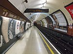 Charing Cross
 Embankment
 Waterloo
 (c) Ashley Dace, CC BY-SA 2.0Lambeth North
 Elephant & Castle
 Interiör från ett tåg på Bakerloo linjen
Referenser
- ^ Matters, Transport for London | Every Journey. ”A brief history of the Underground” (på engelska). Transport for London. https://tfl.gov.uk/corporate/about-tfl/culture-and-heritage/londons-transport-a-history/london-underground/a-brief-history-of-the-underground. Läst 3 juli 2018.
| |||||||||||||
| |||||||
Media som används på denna webbplats
.svg)

This is the "empty element" of the Icons for railway descriptions (see there for further informations). The original syntax of Wikipedia:Route diagram templates filled all empty spaces in a diagram with this file (all BSicons were 20x20px). For those cells where an icon ID was provided, some "File:BSicon_ID.svg" were used, and where there was no ID, "File:BSicon_.svg" was substituted. Many major Wikipedias has since upgraded the syntax so that just an empty table cell is used (incl. En.WP).

Författare/Upphovsman: Swen Johansson, Licens: CC BY-SA 4.0
Interiör från ett tåg på Bakerloo-linjen

underground tunnel stop

Författare/Upphovsman: Sunil060902, Licens: CC BY-SA 3.0
Charing Cross tube station Bakerloo line southbound platform looking north

Underground tunnel terminal station

Underground terminal station
.svg)
TfL Roundel for the Jubilee line. Uses colours from {{LUL color}}
.svg)
TfL Roundel for the Victoria line. Uses colours from {{LUL color}}
This is a logo owned by Transport for London for London Overground.

underground stop


.svg)
TfL Roundel for the District line. Uses colours from {{LUL color}}


Författare/Upphovsman: Sunil060902, Licens: CC BY-SA 3.0
Embankment tube station northbound Bakerloo line platform looking south

Författare/Upphovsman: Romazur, Licens: CC BY-SA 3.0
Regent's Park tube station, interior (2013).

Författare/Upphovsman: Sunil060902, Licens: CC BY-SA 3.0
Piccadilly Circus tube station Bakerloo line northbound platform looking south

ex underground tunnel straight track

(c) Ashley Dace, CC BY-SA 2.0
Lambeth North Underground Railway station The Tube station in London, taken while on a History Trip to the War museum and British Museum. This was my first time on the tube and my first photo of the tube.
.jpg)
Författare/Upphovsman: Chris Sampson, Licens: CC BY 2.0
WATERLOO-2 020909 CPS
.svg)
TfL Roundel for the Metropolitan line. Uses colours from {{LUL color}}
.svg)
TfL Roundel for the Bakerloo line. Uses official colours from [1]

Författare/Upphovsman: Sunil060902, Licens: CC BY-SA 3.0
Oxford Circus tube station Bakerloo line southbound platform looking north

.svg)
TfL Roundel for the Hammersmith & City line. Uses colours from {{LUL color}}

underground tunnel station
.svg)
TfL Roundel for the Northern line. Uses colours from {{LUL color}}

Underground station
.svg)
.svg)
TfL Roundel for the Waterloo & City line. Uses colours from {{LUL color}}
.svg)
TfL Roundel for the Piccadilly line. Uses colours from {{LUL color}}

Författare/Upphovsman: Sunil060902, Licens: CC BY-SA 3.0
Elephant & Castle tube station western Bakerloo line platform looking south towards the sidings south of the station.
.svg)