Baker City
| Baker City | |
| city | |
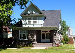
Ed Rand House | |
| Land | |
|---|---|
| Delstat | Oregon |
| County | Baker County |
| Höjdläge | 1 052 m ö.h. |
| Koordinater | 44°46′30″N 117°50′4″V / 44.77500°N 117.83444°V |
| Yta | 18,5 km² (2010) |
| - land | 18,5 km² |
| - vatten | 0,0 km² |
| Folkmängd | 9 828 (2010) |
| Befolkningstäthet | 531 invånare/km² |
| Tidszon | PST (UTC-8) |
| - sommartid | PDT (UTC-7) |
| ZIP-kod | 97814 |
| Riktnummer | 541 |
| FIPS | 4103650 |
| Geonames | 5712169 |
Ortens läge i Oregon | |
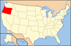
Oregons läge i USA | |
| Webbplats: http://www.bakercity.com/ | |
Baker City är administrativ huvudort i Baker County i Oregon.[1][2] Orten har fått sitt namn efter politikern Edward Dickinson Baker som stupade i amerikanska inbördeskriget.[3] Enligt 2010 års folkräkning hade Baker City 9 828 invånare.[4]
Källor
- ^ Oregon County Map with County Seat Cities. Geology.com Geoscience News and Information. Läst 26 november 2016.
- ^ Profile for Baker City, Oregon. ePodunk. Läst 26 november 2016.
- ^ Edward Dickinson Baker. History of the Restoration Movement. Läst 26 november 2016.
- ^ 2010 Census Population of Baker City, Oregon Arkiverad 26 november 2016 hämtat från the Wayback Machine.. Census Viewer. Läst 26 november 2016.
|
Media som används på denna webbplats
Shiny red button/marker widget. Used to mark the location of something such as a tourist attraction.
Författare/Upphovsman: Huebi, Licens: CC BY 2.0
Map of United States with Oregon highlighted.
Författare/Upphovsman: Ian Poellet, Licens: CC BY-SA 3.0
The historic Ed Rand House (built 1909), located at 1700 4th Street in Baker City, Oregon, United States, is listed on the US National Register of Historic Places.
|
This is an image of a place or building that is listed on the National Register of Historic Places in the United States of America. Its reference number is 81000709. |
Författare/Upphovsman: Alexrk2, Licens: CC BY 3.0
Den här Det karta skapades med GeoTools.


