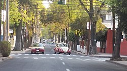
Azcapotzalco
| Den här artikeln behöver källhänvisningar för att kunna verifieras. (2024-01) Åtgärda genom att lägga till pålitliga källor (gärna som fotnoter). Uppgifter utan källhänvisning kan ifrågasättas och tas bort utan att det behöver diskuteras på diskussionssidan. |
| Azcapotzalco | ||
| Stadsdel | ||
© ProtoplasmaKid / Wikimedia Commons, CC BY-SA 4.0 | ||
| ||
| Land | ||
|---|---|---|
| Delstat | Distrito Federal | |
| Koordinater | 19°29′14″N 99°11′16″V / 19.48731°N 99.18766°V | |
| Tidszon | CST (UTC-6) | |
| - sommartid | CDT (UTC-5) | |
| Geonames | 8379132 | |
Läge i Mexiko | ||
Azcapotzalco är en av Mexico Citys 16 distrikt, delegación. Namnet betyder Myrstack på nahuatl. Området ligger i norra Distrito Federal och gränsar till Estado de México.
En av de större vägarna är Periférico.
| |||||
|
Media som används på denna webbplats
Författare/Upphovsman: Tkgd2007, Licens: CC BY-SA 3.0
A new incarnation of Image:Question_book-3.svg, which was uploaded by user AzaToth. This file is available on the English version of Wikipedia under the filename en:Image:Question book-new.svg
Författare/Upphovsman: Carport, Licens: CC BY 3.0
Physical location map of Mexico
Shiny red button/marker widget. Used to mark the location of something such as a tourist attraction.
© ProtoplasmaKid / Wikimedia Commons, CC BY-SA 4.0
Azcapotzalco avenue, Mexico City.
Azcapotzalco borough in México City
Logotipo de la Alcaldía Azcapotzalco


