Aveiro
| Aveiro | |||
| Stad | |||
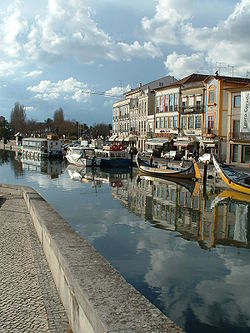
En av kanalerna i Aveiro | |||
| |||
| Land | |||
|---|---|---|---|
| Underregion | Baixo Vouga | ||
| Distrikt | Aveiro | ||
| Flod | Vouga | ||
| Koordinater | 40°38′N 8°39′V / 40.633°N 8.650°V | ||
| Area | 199,77 km² | ||
| Folkmängd | 73 559 (2006)[1] | ||
| Befolkningstäthet | 368 invånare/km² | ||
| Grundades (eller fick stadsrättigheter) | 1515 | ||
| Geonames | 8010417 2742611 | ||
| Gammal provins | Beira Litoral | ||
| Kommunal helgdag | 12 maj | ||
| Antal församlingar | 14 | ||
Aveiros läge i Portugal | |||
| Webbplats: http://www.cm-aveiro.pt/ | |||
Aveiro (portugisiskt uttal: [aˈvejɾu] or [ɐˈvɐjɾu] (![]() lyssna)) är en stad och kommun i mellersta Portugal, belägen vid atlantkusten. Staden är huvudorten i Aveiros kommun och residensstad i Aveiros distrikt. [2]
lyssna)) är en stad och kommun i mellersta Portugal, belägen vid atlantkusten. Staden är huvudorten i Aveiros kommun och residensstad i Aveiros distrikt. [2]
Aveiros kommun har 80 978 invånare. [3]
Etymologi
Namnet Aveiro kommer från det latinska ortsnamnet Averius, som i sin tur kommer från det keltiska ordet aber, med betydelse "flodutmynning". [4]
Stadsdelar
Staden Aveiro är indelat i 10 stadsdelar och kommundelar - freguesias. [5]

- Aradas
- Cacia
- Eixo e Eirol
- Esgueira
- Glória e Vera Cruz
- Oliveirinha
- Requeixo, Nossa Senhora de Fátima e Nariz
- Santa Joana
- São Bernardo
- São Jacinto
Kommunikationer

Motorvägen A 1 passerar Aveiro och leder norrut till Porto och söderut till Lissabon. Motorvägen A 25 utgår från staden och går österut mot Viseu och Guarda. [6] [7]
Från järnvägsstationen i Aveiro utgår tågtrafik mot Porto, Braga, Guimarães, Lisboa och Faro. [8]
Porto de Aveiro är stadens hamn. [9] [10]
Referenser
- ^ Instituto Nacional de Estatística uppgifter från 2006.
- ^ ”Aveiro” (på portugisiska). Infopédia. Porto Editora. https://www.infopedia.pt/apoio/artigos/$aveiro?uri=toponimia/Aveiro. Läst 11 maj 2022.
- ^ ”Censos 2021 - Resultados provisórios” (på portugisiska). Censos 2021. INE (Portugals statistiska centralbyrå). https://www.ine.pt/scripts/db_censos_2021.html. Läst 11 maj 2022.
- ^ ”Aveiro” (på portugisiska). Infopédia. Porto Editora. https://www.infopedia.pt/dicionarios/toponimia/Aveiro. Läst 11 maj 2022.
- ^ ”Mapa dos municípios (Karta över kommunerna) - Aveiro” (på portugisiska). Associacão Nacional dos Municípios Portugueses (Portugisiska kommunförbundet). https://www.anmp.pt/municipios/municipios/municipios-de-a-a-v/. Läst 4 juni 2022.
- ^ ”Estradas de Portugal (Vägkarta – Portugal)” (på portugisiska). Infraestruturas de Portugal. Arkiverad från originalet den 28 januari 2014. https://web.archive.org/web/20140128080223/http://www.estradasdeportugal.pt/index.php/pt/phoca-download-/category/10-prn?download=411%3Aprn-2000. Läst 3 juni 2022.
- ^ ”Concessões das Infraestruturas Rodoviárias – Portugal 2019” (på portugisiska). AMT – Autoridade da Mobilidade e dos Transportes. sid. 30-31. https://www.amt-autoridade.pt/media/3012/relatorio_das_concessoes_2019_amt.pdf. Läst 3 juni 2022.
- ^ ”Aveiro, Portugal” (på engelska). Google Maps. https://www.google.com/maps/place/Aveiro,+Portugal/@40.6356357,-8.6938956,18246m/data=!3m1!1e3!4m5!3m4!1s0xd23980ed5b2e78d:0x3042e1cd013c1f07!8m2!3d40.6405055!4d-8.6537539?hl=en. Läst 4 juni 2022.
- ^ ”Port facilities” (på engelska). Porto de Aveiro. https://portodeaveiro.pt/instalacoes-portuarias/en/. Läst 4 juni 2022.
- ^ ”Aveiro” (på engelska). Find a Port. https://www.findaport.com/port-of-aveiro. Läst 4 juni 2022.
Externa länkar
 Wikimedia Commons har media som rör Aveiro.
Media som används på denna webbplats
Flag of Portugal, created by Columbano Bordalo Pinheiro (1857–1929), officially adopted by Portuguese government in June 30th 1911 (in use since about November 1910). Color shades matching the RGB values officially reccomended here. (PMS values should be used for direct ink or textile; CMYK for 4-color offset printing on paper; this is an image for screen display, RGB should be used.)
Författare/Upphovsman: Dmpalves, Licens: CC BY-SA 4.0
Entrada para o Terminal Norte do Porto de Aveiro. Foto obtida por drone, autoria de Carlos Pelicas.
Författare/Upphovsman: Gazilion, Licens: CC0
Civil parishes in the municipality of Aveiro (Portugal)
Sources:
- Diário da República, Administrative reorganization of the civil parishes' territory, Law n. 11-A/2013, from 28th January.
- Direcção-Geral do Território, Official Administrative Chart of Portugal (CAOP), version 2013: Mainland (http://www.dgterritorio.pt/ficheiros/cadastro/caop/caop_download/caop_2013_0/caop2013cont_zip_2)
Författare/Upphovsman: FilipeFalcão, Licens: CC BY-SA 3.0
Name of a municipality of Portugal, with more uses.


