Australiska Antarktis
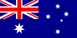
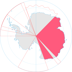
Australiska Antarktis (engelska: Australian Antarctic Territory, AAT) är ett landområde i Antarktis som Australien ensidigt gör anspråk på.
Geografi
Området ligger i Östantarktis och sträcker sig från 160° Ö till 142° Ö och från 136° Ö till 45° Ö (mellan 136° och 142° ligger franska Adélieland). [1][2]
Inom området ligger:
- Enderby Land
- Kemp Land
- Mac. Robertson Land
- Princess Elizabeth Land
- Vilhelm II:s land
- Queen Mary Land
- Wilkes Land
- George V Land
- Oates Land
AAT omfattar västra AAT och östra AAT samt två öområden Heard- och McDonaldöarna (Heardöarna yta: 368 km², McDonaldöarna yta: 4,5 km²) utanför fastlandet och hela området omfattar cirka 6 120 800 km² (cirka 14 gånger Sveriges yta).
Området utgör ett så kallat "Australian external territory" och förvaltas direkt av Australian Government Antarctic Division med kontor på Tasmanien.
Historia
Australien har gjort anspråk på området sedan den 13 juni 1933. Den 13 februari 1954 öppnades Mawson Station, Australiens första permanent bemannade forskningsstation. 1957 påbörjades seden att ge ut Australian Antarctis-frimärken, en sed som sedan dess har fortsatt. Frimärkena är även giltiga i Australien, så i praktiken är det "bara" australiska frimärken med motiv och text som anknyter till Antarktis.
Referenser
- ^ Worldstatesmen.org (läst 21 oktober 2010)
- ^ Commonwealth secretariat Arkiverad 29 april 2010 hämtat från the Wayback Machine. (läst 21 oktober 2010)
Externa länkar
- Om Australian Government Antarctic Division
- Om Heard- och McDonaldöarna
- Om Heardöarna
- Om McDonaldöarna
| |||||||||||
Media som används på denna webbplats
State flag and government ensign (internal waters only) of Victoria.
Flago de la Kokosinsuloj, uzo ne oficiala
State flag and government ensign (internal waters only) of Queensland.
FIAV 110010.svg:
(c) Lokal_Profil, CC BY-SA 2.5
Map showing the territorial claim to Antarctica by the country in the filename. Also on the map are is the 60° S Parallel, Antarctic Circle, 0/180 latitude line and (in red) the borders of the claims by other states.
Författare/Upphovsman: user:Dbenbenn, Licens: CC0
The flag of the Australian Capital Territory
It is from openclipart.org, specifically australia_capital_territory.svg by Caleb Moore
The flag of the Northern Territory (adopted on July 1, 1978 on the first day of self-government) was designed by the Australian artist Robert Ingpen, of Drysdale Victoria, after consultation with members of the community at the invitation of the Northern Territory Government. The flag incorporates the three official Territorian colours of black, white and ochre and is divided into two panels, black at the hoist side taking up one third the length of the flag while the remainder is equal to two third the length of the flag in ochre. The black panel display the five white stars that form the constellation of the Southern Cross, using the Victorian configuration of the Southern Cross with stars having between five to eight points. The flag also features the official Northern Territory floral emblem on the red ochre panel, a stylisation of the Sturt's Desert Rose, which uses seven petals encircling a seven-pointed black star of the federation in the centre. The seven petals symbolises the six Australian states plus the Northern Territory. The Northern Territory Flag was the first official flag that did not contain the Union Jack.
