Aurlands kommun
| Aurlands kommun | |||
| Aurland kommune | |||
| Kommun | |||
.jpg) | |||
| |||
| Land | |||
|---|---|---|---|
| Fylke | Vestland fylke | ||
| Koordinater | 60°54′0″N 7°10′0″Ö / 60.90000°N 7.16667°Ö | ||
| Centralort | Aurlandsvangen | ||
| Area | 1 516,52 km² (2020)[1] | ||
| - land | 1 376,27 km² (2020) | ||
| - vatten | 140,25 km² | ||
| Folkmängd | 1 775 (2023)[2] | ||
| Befolkningstäthet | 1 invånare/km² | ||
| Politik | |||
| - Kommunstyrelsens ordförande | Trygve Skjerdal (2019–) | ||
| Tidszon | CET (UTC+1) | ||
| - sommartid | CEST (UTC+2) | ||
| Kommunkod | 4641 (2020–) 1421 (–2019) | ||
| Geonames | 3162403 | ||
| Målform | nynorska | ||
 Aurlands kommun i Vestland fylke. | |||
 (c) Karte: NordNordWest, Lizenz: Creative Commons by-sa-3.0 de Vestland fylke i Norge. | |||
| Wikimedia Commons: Aurland | |||
| Webbplats: https://aurland.kommune.no/ | |||
| Redigera Wikidata | |||
Aurlands kommun (norska: Aurland kommune) är en kommun i Vestland fylke i västra Norge. Tätorten Aurlandsvangen utgör kommunens centralort.
Administrativ historik
Aurlands kommun upprättades den 1 januari 1838 (som Urland formannskapsdistrikt) när Formannskapslovene från 1837 trädde i kraft. Kommunens gränser har förblivit oförändrade sedan dess.[3]
Tätorter
I Aurlands kommun finns två tätorter:[4]
- Aurlandsvangen (centralort)
- Flåm
Socknar
Inom Norska kyrkan är Aurlands kommun indelad i fyra socknar:[5]
- Flåms socken
- Nærøy socken
- Undredals socken
- Vangens socken
Socknarna ingår i Sogns prosteri i Bjørgvins stift.[5]
Bilder

 Flåm.
Flåm.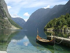 Nærøyfjorden vid Gudvangen.
Se även
- Flåmsbanan
- Aurlandsdalen
- Lærdalstunneln
- Vangens kyrka
Källor
- ^ Statens kartverk, Arealstatistikk for Norge 2020, Statens kartverk, 20 december 2019, läs online.[källa från Wikidata]
- ^ 07459: Alders- og kjønnsfordeling i kommuner, fylker og hele landets befolkning (K) 1986 - 2023 (på norskt bokmål), Statistisk sentralbyrå, 21 februari 2023, läs online.[källa från Wikidata]
- ^ ”Historisk oversikt over endringer i kommune- og fylkesinndelingen” (PDF). Statistisk sentralbyrå. Maj 1999. https://www.ssb.no/a/publikasjoner/pdf/rapp_9913/rapp_9913.pdf.
- ^ Kart fra Statistisk sentralbyrå
- ^ [a b] Store norske leksikon
Externa länkar
- Officiell webbplats
 Wikimedia Commons har media som rör Aurlands kommun.
| |||||||
| ||||||||||
Media som används på denna webbplats
.svg)
Författare/Upphovsman: Gutten på Hemsen, Licens: CC0
Flag of Norway with colors from the previous version on Commons. This file is used to discuss the colors of the Norwegian flag.

Författare/Upphovsman: Leif, Licens: CC BY 2.0
Nærøyfjorden frå Gudvangen

Flag of Aurland municipality

Coat of arms for the Norwegian municipality of Aurland.

(c) Karte: NordNordWest, Lizenz: Creative Commons by-sa-3.0 de
Location of county Vestland in Norway (2024)

Coat of arms for Vestland county, Norway
Författare/Upphovsman: Markus Trienke, Licens: CC BY-SA 2.0
Aurlandsfjord
Författare/Upphovsman: Jay1279, Licens: CC0
Map of Aurland municipality in Vestland county, Norway

Coat of arms for Sogn og Fjordane county (fylke), Norway.The coat of arms were granted on 23 September 1983. The arms show the geographical layout of the county: three large fjords protruding into the land. The three fjords are the Nordfjord, Sunnfjord and Sognefjord. As nearly all villages and towns are situated on one of these fjords and the name of the county is based on the fjords.

Författare/Upphovsman: Dan Lundberg, Licens: CC BY-SA 2.0
Looking back down the Flåmsdalen valley towards Aurlandsfjord from Brekkefossen waterfall. The tiny town of Flåm (pronounced ‘flome’) is just out of sight below the edge of the fields at the head of Aurlandsfjord.
On Google Earth: Flåm on Aurlandsfjord 60°51'49.08"N, 7° 6'55.68"E
Brekkefossen waterfall 60°51'7.98"N, 7° 5'59.06"E