Ault
| Ault | ||
| Kommun | ||
 | ||
| ||
| Land | ||
|---|---|---|
| Region | Hauts-de-France | |
| Departement | ||
| Arrondissement | Abbeville | |
| Kanton | Ault | |
| Koordinater | 50°6′N 1°27′Ö / 50.100°N 1.450°Ö | |
| Yta | 5,99 km²[1] | |
| Folkmängd | 1 369 ()[2] | |
| Befolkningstäthet | 229 invånare/km² | |
| Tidszon | CET (UTC+1) | |
| - sommartid | CEST (UTC+2) | |
| Postnummer | 80460 | |
| INSEE | 80039 | |
| Geonames | 6451286 | |
| OSM-karta | 396664 | |
 Kommunens läge i regionen Hauts-de-France i Frankrike | ||
| Webbplats: http://www.ault.fr | ||

Ault är en kommun i departementet Somme i regionen Hauts-de-France i norra Frankrike. Kommunen ligger i kantonen Ault som tillhör arrondissementet Abbeville. År 2022 hade Ault 1 369 invånare.
Befolkningsutveckling
Antalet invånare i kommunen Ault
 Referens: INSEE[3] |
Galleri
 Stranden
 Fyren
Fyren
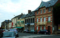 Storgatan mot sjön
 Gatan mot kyrkan Saint-Pierre
 Kyrkan Saint-Pierre
Se även
Källor
- ^ Répertoire géographique des communes, Institut national de l'information géographique et forestière, läst: 26 oktober 2015.[källa från Wikidata]
- ^ Populations légales 2022, Institut National de la Statistique et des Études Économiques, 19 december 2024.[källa från Wikidata]
- ^ Chiffres clés - Évolution et structure de la population hämtat från the Wayback Machine (arkiverat 4 maj 2012).
Externa länkar
 Wikimedia Commons har media som rör Ault.
Media som används på denna webbplats


Författare/Upphovsman: Eric Gaba (Sting - fr:Sting), Licens: CC BY-SA 4.0
Blank physical map of metropolitan France for geo-location purpose.
Scale : 1:14 816 000 (accuracy : about 3,7 km) for the bathymetry. More maps of France, view → Commons Atlas of France.

Shiny red button/marker widget. Used to mark the location of something such as a tourist attraction.
Författare/Upphovsman:
|
Map data (c) OpenStreetMap contributors, CC-BY-SA _French_municipality_map.svg) • Shape files infrastructure: railway, highways, water: all originally by OpenStreetMap contributors. Status december 2011 *note: shown commune boundaries are from OSM dump May 2012; at that time about 90% complete |
Map of French municipality Ault

Författare/Upphovsman: Ricardo Boimare, Licens: CC BY 2.5
Le Bois de Cise et une vue des falaises picardes. Au premier plan et en contrebas de la maison blanche, le Bois de Cise et son accès à la mer. Au second plan, une vue de la commune de Ault (Somme), à laquelle le bois est rattaché sur le plan administratif. On aperçoit ensuite le bourg d'Onival et tout au fond, le cordon littoral qui forme le hâble d'Ault.

Författare/Upphovsman: isamiga76 + Markus3 (Marc ROUSSEL) (retaillage/"crop" et traitement numérique), Licens: CC BY 2.0
Ault (Somme, France).
La "Grande Rue" descend vers la mer.

Författare/Upphovsman: Paul Hermans, Licens: CC BY-SA 3.0
De Sint-Petruskerk in Ault, Frankrijk

Le Bois-de-Cise sous la neige
Författare/Upphovsman: Michiel1972, Licens: CC BY-SA 3.0
Population - Municipality code 80039.svg
Population Census 1962-2008
Författare/Upphovsman: Chatsam, Licens: CC BY-SA 3.0
blason de la commune d'ault somme france

Författare/Upphovsman: isamiga76 + Markus3 (Marc ROUSSEL) (retaillage/"crop" et traitement numérique), Licens: CC BY 2.0
Ault (Somme, France).
La "Grande Rue" remonte vers l'église.

Författare/Upphovsman: isamiga76 from Saint Pierre Lavis,Normandie, France, Licens: CC BY 2.0
Faro de Ault, en la región de Somme, Francia