Artarmon
| Artarmon | |
| Förort | |
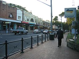
Artarmon vid järnvägsstationen. | |
| Land | |
|---|---|
| Delstat | New South Wales |
| County | Cumberland |
| Parish | Willoughby |
| LGA | City of Willoughby |
| Koordinater | 33°48′43″S 151°11′05″Ö / 33.81194°S 151.18472°Ö |
| Folkmängd | 8 642 (2011)[1] |
| Tidszon | AEST (UTC+10) |
| - sommartid | AEDT (UTC+11) |
| Postnummer | 2064 |
| Geonames | 2177626 |
Artarmons läge i New South Wales | |
Artarmon är en förort till staden Sydney i New South Wales i Australien. Folkmängden uppgick till 8 642 år 2011.
Kommunikationer
Järnväg
Artarmon betjänas av järnvägsstationen Artarmon Railway Station som ligger på järnvägslinjerna North Shore Line samt Northern Line
Väg
Arncliffe är belägen på landsvägen Pacific Highway samt motorvägen Gore Hill Freeway.
Befolkningsutveckling
Referenser
- ^ Australian Bureau of Statistics. ”2011 Census QuickStats: Artarmon” (på engelska). http://www.censusdata.abs.gov.au/census_services/getproduct/census/2011/quickstat/SSC10058?opendocument&navpos=220. Läst 4 augusti 2012.
Befolkningsutvecklingskällor
- Australian Bureau of Statistics. ”2001 Census QuickStats : Artarmon (State Suburb)” (på engelska). http://www.censusdata.abs.gov.au/ABSNavigation/prenav/ProductSelect?newproducttype=QuickStats&btnSelectProduct=View+QuickStats+%3E&collection=Census&period=2001&areacode=SSC11061&geography=&method=&productlabel=&producttype=&topic=&navmapdisplayed=true&javascript=true&breadcrumb=LP&topholder=0&leftholder=0¤taction=201&action=401&textversion=false. Läst 4 augusti 2012.
- Australian Bureau of Statistics. ”2006 Census QuickStats : Artarmon (State Suburb)” (på engelska). http://www.censusdata.abs.gov.au/ABSNavigation/prenav/ProductSelect?newproducttype=QuickStats&btnSelectProduct=View+QuickStats+%3E&collection=Census&period=2006&areacode=SSC11025&geography=&method=&productlabel=&producttype=&topic=&navmapdisplayed=true&javascript=true&breadcrumb=LP&topholder=0&leftholder=0¤taction=201&action=401&textversion=false. Läst 8 maj 2012.
- Australian Bureau of Statistics. ”2011 Census QuickStats: Artarmon” (på engelska). http://www.censusdata.abs.gov.au/census_services/getproduct/census/2011/quickstat/SSC10058?opendocument&navpos=220. Läst 4 augusti 2012.
Externa länkar
 Wikimedia Commons har media som rör Artarmon.
Media som används på denna webbplats
Shiny red button/marker widget. Used to mark the location of something such as a tourist attraction.
Författare/Upphovsman: Tentotwo, Licens: CC BY-SA 3.0
Relief location map of New South Wales, Australia Equidistant cylindrical projection, latitude of true scale 32.82° S (equivalent to equirectangular projection with N/S stretching 119 %). Geographic limits of the map:
- N: 27.9° S
- S: 37.8° S
- W: 140.6° E
- E: 153.9° E
Hampden Road, Artarmon, New South Wales facing north outside Artarmon railway station.


