Arsia Mons
| Den här artikeln behöver källhänvisningar för att kunna verifieras. (2015-09) Åtgärda genom att lägga till pålitliga källor (gärna som fotnoter). Uppgifter utan källhänvisning kan ifrågasättas och tas bort utan att det behöver diskuteras på diskussionssidan. |

Arsia Mons är den sydligaste av tre vulkaner (kända som Tharsis Montes) på Mars.
| ||||||||||||||||||||||||||||||||||||||||||||||||||||||||
Media som används på denna webbplats
Författare/Upphovsman: Tkgd2007, Licens: CC BY-SA 3.0
A new incarnation of Image:Question_book-3.svg, which was uploaded by user AzaToth. This file is available on the English version of Wikipedia under the filename en:Image:Question book-new.svg
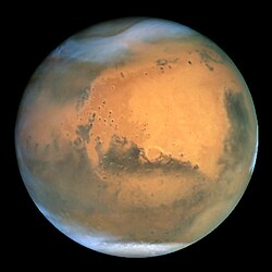
NASA's Hubble Space Telescope took the picture of Mars on June 26, 2001, when Mars was approximately 68 million kilometers (43 million miles) from Earth — the closest Mars has ever been to Earth since 1988. Hubble can see details as small as 16 kilometers (10 miles) across. The colors have been carefully balanced to give a realistic view of Mars' hues as they might appear through a telescope. Especially striking is the large amount of seasonal dust storm activity seen in this image. One large storm system is churning high above the northern polar cap (top of image), and a smaller dust storm cloud can be seen nearby. Another large dust storm is spilling out of the giant Hellas impact basin in the Southern Hemisphere (lower right).
Författare/Upphovsman: Martin Pauer (Power), Licens: CC BY 3.0
Arsia Mons (Mars) topography


