Armour, South Dakota
| Armour | |
| city | |
| Land | |
|---|---|
| Delstat | South Dakota |
| County | Douglas County |
| Höjdläge | 466 m ö.h. |
| Koordinater | 43°19′7″N 98°20′48″V / 43.31861°N 98.34667°V |
| Yta | 2,46 km² (2010) |
| - land | 2,43 km² |
| - vatten | 0,03 km² |
| Folkmängd | 699 (2010) |
| Befolkningstäthet | 288 invånare/km² |
| Tidszon | CST (UTC-6) |
| - sommartid | CDT (UTC-5) |
| ZIP-kod | 57313 |
| Riktnummer | 605 |
| FIPS | 4602260 |
| Geonames | 5226045 |
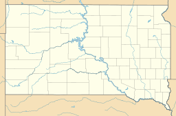
Ortens läge i South Dakota | |
South Dakotas läge i USA | |
| Webbplats: http://www.armoursd.com/ | |
Armour är administrativ huvudort i Douglas County i South Dakota.[1] Orten har fått sitt namn efter affärsmannen Philip Armour.[2][3] Enligt 2010 års folkräkning hade Armour 699 invånare.[4]
Källor
- ^ South Dakota County Map with County Seat Cities. Geology.com Geoscience News and Information. Läst 14 december 2016.
- ^ Profile for Armour, South Dakota. ePodunk. Läst 14 december 2016.
- ^ Armour, SD. Map Quest. Läst 14 december 2016.
- ^ 2010 Census Population of Armour, South Dakota Arkiverad 20 december 2016 hämtat från the Wayback Machine.. Census Viewer. Läst 14 december 2016.
|
Media som används på denna webbplats
Shiny red button/marker widget. Used to mark the location of something such as a tourist attraction.
Författare/Upphovsman: Huebi, Licens: CC BY 2.0
Map of USA with South Dakota highlighted
Författare/Upphovsman: Sdgjake, Licens: CC BY-SA 3.0
The town sign for Armour, South Dakota along Highway 281. The Douglas County Courthouse and Museum are visible in the background.
Författare/Upphovsman: Alexrk, Licens: CC BY 3.0
Location map of South Dakota, USA


