Arlesey
| Arlesey | |
| Ort | |
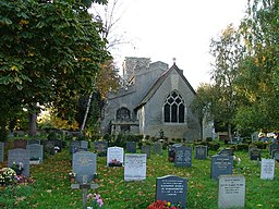
(c) Robin Hall, CC BY-SA 2.0 Church of St Peter i Arlesey | |
| Land | |
|---|---|
| Riksdel | England |
| Region | Östra England |
| Enhetskommun | Central Bedfordshire |
| Ceremoniellt grevskap | Bedfordshire |
| Koordinater | 52°00′28″N 00°15′42″V / 52.00778°N 0.26167°V |
| Area | 1,35 km²[1] |
| Folkmängd | 5 584 (2011)[1] |
| Befolkningstäthet | 4 136 invånare/km² |
| Tidszon | WET (UTC+0) |
| - sommartid | BST (UTC+1) |
| Postort | ARLESEY |
| Postnummer | SG15 |
| Riktnummer | 01462 |
| Geonames | 2657073 7298857 |
Contains Ordnance Survey data © Crown copyright and database right, CC BY-SA 3.0 Arleseys läge i Bedfordshire | |
| Webbplats: www.arleseytc.co.uk | |
Arlesey är en ort och civil parish i grevskapet Bedfordshire i England. Orten ligger i distriktet Central Bedfordshire, nära gränsen till Hertfordshire. Tätorten (built-up area) hade 5 584 invånare vid folkräkningen år 2011.[1] Arlesey nämndes i Domedagsboken (Domesday Book) år 1086, och kallades då Alricesei.[2]
Referenser
- ^ [a b c] ”Arlesey Built-up area - Local Area Report - Nomis”. www.nomisweb.co.uk. https://www.nomisweb.co.uk/reports/localarea?compare=E34002727. Läst 16 juni 2020.
- ^ ”The Domesday Book Online - Bedfordshire A-H”. www.domesdaybook.co.uk. http://www.domesdaybook.co.uk/bedfordshire1.html#arlesey. Läst 16 juni 2020.
Externa länkar
 Wikimedia Commons har media som rör Arlesey.
- Officiell webbplats
Media som används på denna webbplats
Shiny red button/marker widget. Used to mark the location of something such as a tourist attraction.
(c) Robin Hall, CC BY-SA 2.0
Parish Church of St Peter - Church End Arlesey. Tucked away at the end of Arlesey (which according to local legend, is the longest village in the UK). This claim can be checked using Google if you like - it seems not to be true. The church is a bit run down and has some old wooden crosses in the graveyard.
Contains Ordnance Survey data © Crown copyright and database right, CC BY-SA 3.0
Map of Bedfordshire, UK with the following information shown:
- Administrative borders
- Coastline, lakes and rivers
- Motorways, primary routes and railways
- Urban areas
Equirectangular map projection on WGS 84 datum, with N/S stretched 160%
Geographic limits:
- West: 0.8W
- East: 0.05W
- North: 52.33N
- South: 51.8N


