Ammanford
| Ammanford (Rhydaman) | |
| Ort | |
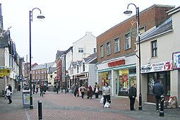
(c) Nigel Davies, CC BY-SA 2.0 Ammanford | |
| Land | |
|---|---|
| Riksdel | Wales |
| Kommun | Carmarthenshire |
| Koordinater | 51°47′34″N 3°59′18″V / 51.7927°N 3.9883°V |
| Area | |
| - tätort | 3,5 km² |
| - community | 3,1 km² |
| Folkmängd | |
| - tätort | 7 945 (2011)[1] |
| - community | 5 411 (2011)[2] |
| Befolkningstäthet | |
| - tätort | 2 270 invånare/km² |
| - community | 1 745 invånare/km² |
| Tidszon | UTC (UTC+0) |
| - sommartid | BST (UTC+1) |
| Geonames | 2657345 7291026 |
Läge i Storbritannien | |
Ammanford (walesiska: Rhydaman) är en ort och community i Storbritannien. Den ligger 19 km norr on Swansea i kommunen Carmarthenshire och riksdelen Wales, i den södra delen av landet, 270 km väster om huvudstaden London.
En del av tätorten Ammanford ligger i Betws coummunity.
Källor
- ^ ”Ammanford Built-up area sub division”. Office for National Statistics. https://www.nomisweb.co.uk/reports/localarea?compare=W38000018. Läst 9 juli 2022.
- ^ ”Ammanford Parish”. Office for National Statistics. https://www.nomisweb.co.uk/reports/localarea?compare=W04000491. Läst 9 juli 2022.
Externa länkar
 Wikimedia Commons har media som rör Ammanford.
Media som används på denna webbplats
Författare/Upphovsman: Alexrk2, Licens: CC BY-SA 3.0
Location map of the United Kingdom
Shiny red button/marker widget. Used to mark the location of something such as a tourist attraction.
(c) Nigel Davies, CC BY-SA 2.0
Quay Street, Ammanford (Recreated) Looking north up Quay St, from near the junction with Hall St and angled towards the east side.
This is a recreation of the 1965 photo at Frith: http://www.francisfrith.com/search/wales/dyfed/ammanford/photos/ammanford_A186091.htm
The street is now pedestrianised, and the terraced red brick buildings in the extreme distance have had their pinnacled dormer windows removed when the roof was replaced.


