Amerys shelfis


Amerys shelfis (engelska: Amery Ice Shelf) är ett shelfisområde i östra Antarktis. Området är den tredje största shelfisen efter Ross shelfis och Filchner-Rønnes shelfis.
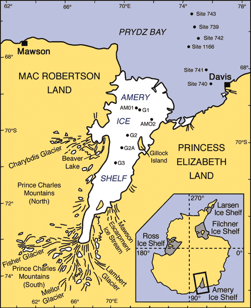
Geografi
Ameryshelfisen ligger i Östantarktis vid viken Prydz Bay mellan Mac Robertson land och Princess Elizabeth land.[1][2] Området har en sammanlagd yta på cirka 62 620 km² med en längd på cirka 400 km och en bredd på 175 km som mest. Shelfisen sträcker sig mellan cirka 69° till 70° S och 72° till 75° Ö-
Området matas på med is av bland annat Lambertglaciären, Fischerglaciären, Charybdisglaciären och Mellorglaciären. Under isen i den östra delen ligger ön Gillock Island.
Historia
Amerys shelfis utforskades och kartlades 1931 av "British Australian and New Zealand Antarctic Research Expedition" (BANZARE) under ledning av Douglas Mawson. Man döpte då området till Cape Amery efter William B. Amery, Storbritanniens högste representant i Australien åren 1925–1928. Först senare kunde man fastslå att området var mycket större och namnet ändrades 1947.
1953 fastställdes det nuvarande namnet av amerikanska "Advisory Committee on Antarctic Names" (US-ACAN, en enhet inom United States Geological Survey).
Referenser
- ^ Geographic Names Information System (GNIS) (läst 18 november 2010)
- ^ Composite Gazetteer of Antarctica (SCAR) (läst 18 november 2010)
Externa länkar
Media som används på denna webbplats
NASA Landsat map of the region around the Lambert glacier in Antarctica
Several glaciers in East Antarctica, including the Lambert Glacier, share the same route to the ocean through the Amery Ice Shelf. Although comprising just a tiny portion of the Antarctic coastline, this ice shelf drains roughly 16 percent of the East Antarctic Ice Sheet. The Amery deposits ice into the ocean through the natural, cyclical process of iceberg calving—a process that can take decades to complete.
The Advanced Land Imager (ALI) on NASA’s Earth Observing-1 (EO-1) satellite captured this natural-color image on January 27, 2012. It shows a portion of the Amery Ice Shelf, where three giant cracks, or rifts, meet. The largest rift runs in the same direction as the ice flow, and widens toward the edge of the ice shelf (image center). Smaller rifts extend toward the east and west, and the tip of the western rift narrows and curves significantly (image lower left).
These rifts lie along the western edge of a feature glaciologists have nicknamed Amery’s “loose tooth.” The tooth is a giant tabular iceberg that has been gradually loosening for more than a decade. The overall cycle of iceberg calving on the Amery Ice Shelf is slow, with the last major calving event occurring in the early 1960s. At that time, Amery released an ice island measuring roughly 140 by 70 kilometers.
Although slow calving of icebergs has been the norm for the ice shelf, a rapid retreat is possible. Although much smaller than Antarctica’s largest ice shelves—the Ross and Filchner-Ronne—the Amery lies several degrees closer to the Equator. It also has some of the same traits as ice shelves that have retreated on the Antarctic Peninsula, such as extensive crevasses (cracks) and annual surface melt streams