Ambleside
| Ambleside | |
| Ort | |
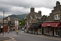
Rydal Road i centrala Ambleside | |
| Land | |
|---|---|
| Riksdel | England |
| Region | Nordvästra England |
| Ceremoniellt grevskap | Cumbria |
| Enhetskommun | Westmorland and Furness |
| Civil parish | Lakes |
| Koordinater | 54°25′55″N 02°57′47″V / 54.43194°N 2.96306°V |
| Area | 1,24 km²[1] |
| Folkmängd | 2 529 (2011)[1] |
| Befolkningstäthet | 2 040 invånare/km² |
| Tidszon | WET (UTC+0) |
| - sommartid | BST (UTC+1) |
| Postort | AMBLESIDE |
| Postnummer | LA22 |
| Riktnummer | 015394 |
| Geonames | 2657360 |
Contains Ordnance Survey data © Crown copyright and database right, CC BY-SA 3.0 Amblesides läge i Cumbria | |
Ambleside är en ort i civil parish Lakes i grevskapet Cumbria i nordvästra England. Orten ligger i distriktet Westmorland and Furness vid sjön Windermeres norra ände. Den ligger i nationalparken Lake District. Tätorten (built-up area) hade 2 529 invånare vid folkräkningen år 2011.[1] Ambleside var en civil parish 1866–1974[2] när blev den en del av Lakes.[3] Civil parish hade 2 562 invånare år 1961.[4]
Namnet kommer ifrån fornnordiskans Á-mel-sǽtr, vilket betyder "flod – sandbank – sommarbetesmark".
Referenser
- ^ [a b c] ”Ambleside Built-up area - Local Area Report - Nomis”. www.nomisweb.co.uk. https://www.nomisweb.co.uk/reports/localarea?compare=E34002509. Läst 14 juni 2020.
- ^ ”Relationships and changes Ambleside CP/Ch through time”. A Vision of Britain through Time. https://visionofbritain.org.uk/unit/10059458. Läst 12 juli 2023.
- ^ ”Westmorland South Registration District”. UKBMD. https://www.ukbmd.org.uk/reg/districts/westmorland%20south.html. Läst 5 januari 2022.
- ^ ”Population statistics Ambleside CP/Ch through time”. A Vision of Britain through Time. https://visionofbritain.org.uk/unit/10059458/cube/TOT_POP. Läst 12 juli 2023.
Externa länkar
 Wikimedia Commons har media som rör Ambleside.
Media som används på denna webbplats
Shiny red button/marker widget. Used to mark the location of something such as a tourist attraction.
Contains Ordnance Survey data © Crown copyright and database right, CC BY-SA 3.0
Map of Cumbria, UK with the following information shown:
- Administrative borders
- Coastline, lakes and rivers
- Roads and railways
- Urban areas
Equirectangular map projection on WGS 84 datum, with N/S stretched 170%
Geographic limits:
- West: 3.80W
- East: 2.10W
- North: 55.20N
- South: 54.02N
Författare/Upphovsman: Diliff, Licens: CC BY-SA 3.0
The main road (Rydal Rd) through Ambleside in the Lake District, Cumbria, England.


