Alliance, Ohio
| Alliance | |
| Stad (city) | |
| Land | |
|---|---|
| Delstat | |
| Höjdläge | 353 m ö.h. |
| Koordinater | 40°54′48″N 81°6′29″V / 40.91333°N 81.10806°V |
| Area | 23,23 km² (2010)[2] |
| Folkmängd | 21 672 (2020)[3] |
| Befolkningstäthet | 933 invånare/km² |
| Grundad | 1854[1] |
| Tidszon | EST (UTC-5) |
| - sommartid | EDT (UTC-4) |
| ZIP-kod | 44601 |
| Riktnummer | 330 |
| GNIS-kod | 1064313 |
| Geonames | 5145607 |
Översiktskarta | |
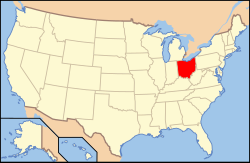
Ohios läge i USA | |
| Wikimedia Commons: Alliance, Ohio | |
| Webbplats: http://www.cityofalliance.com/ | |
| Redigera Wikidata | |
Alliance är en ort i Stark County i delstaten Ohio, USA.
Referenser
- ^ härlett från: Kategori:Orter grundade 1854, läst: 14 november 2018.[källa från Wikidata]
- ^ United States Census Bureau, 2010 U.S. Gazetteer Files, United States Census Bureau, 2010, läst: 9 juli 2020.[källa från Wikidata]
- ^ United States Census Bureau (red.), USA:s folkräkning 2020, läs online, läst: 1 januari 2022.[källa från Wikidata]
Media som används på denna webbplats
Författare/Upphovsman: This version: uploader
Base versions this one is derived from: originally created by en:User:Wapcaplet, Licens: CC BY 2.0
Map of USA with Ohio highlighted
Författare/Upphovsman: Sanfranman59, Licens: CC BY-SA 3.0
Registered Historic Places in Stark County, Ohio.
Glamorgan Castle, 1025 South Union Ave, Alliance, Ohio, USA. Photographed 2008-08-25 from the grounds to the southeast of the building.| Kameraposition | | Se denna och andra närliggande bilder på: OpenStreetMap |
|---|
Författare/Upphovsman: Ruhrfisch and Nyttend, Licens: CC BY-SA 3.0
Map of the municipal and township boundaries of Stark County, Ohio, United States, as of the 2000 census, with the location of the city of Alliance highlighted. Township borders are shown only in unincorporated areas in order to differentiate incorporated and unincorporated areas more clearly.


