Alcochete
| Alcochete | |||
| Stad Kommun | |||
 Utsikt över Tajo från Alcochete | |||
| |||
| Land | |||
|---|---|---|---|
| Region | Storstadsområdet Lissabon (Área Metropolitana de Lisboa) | ||
| Distrikt | Setúbal | ||
| Flod | Tajo | ||
| Koordinater | 38°45′N 8°58′V / 38.750°N 8.967°V | ||
| Area | |||
| - kommun | 128,00 km² | ||
| Folkmängd | |||
| - kommun | 17 569 (2020) | ||
| Grundades (eller fick stadsrättigheter) | 1515 | ||
| Borgmästare | Luís Franco (CDU) | ||
| Geonames | 8010616 | ||
| Gammal provins | Estremadura | ||
| Skyddshelgon | São João Baptista | ||
| Kommunal helgdag | 24 juni | ||
| Antal freguesias | 3 | ||
 Alcochete:s läge i Portugal | |||
| Webbplats: http://www.cm-alcochete.pt | |||
Alcochete (portugisiskt uttal: [alkuˈʃet(ɨ)] (![]() lyssna)) är en stad och kommun i Portugal omkring 40 km ostsydost om Lissabon.[1][2]
lyssna)) är en stad och kommun i Portugal omkring 40 km ostsydost om Lissabon.[1][2]
Kommunen har 17 569 invånare (2020) och en yta på 128 km². Den är belägen i Setúbal-distriktet.[2]
Ortnamnet
Ortnamnet Alcochete härstammar från arabiskans al kuxat (”ugnarna”), syftande på de kalkugnar som användes i området för att producera kalk ur kalksten.[3]
Stadsdelar
Alcochete är indelat i tre freguesias (kommundelar):[2]
- Alcochete
- Samouco
- São Francisco
Bilder
 Alcochete (gatubild)
 Alcochete (gatubild)
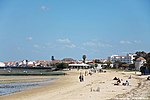 Badstrand i Alcochete
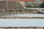 Flamingo-stråk
Referenser
- ^ ”Alcochete” (på portugisiska). Infopédia. Porto Editora. https://www.infopedia.pt/apoio/artigos/$alcochete?uri=toponimia/Alcochete. Läst 28 juni 2022.
- ^ [a b c] ”Mapa dos municípios (Karta över kommunerna) – Alcochete” (på portugisiska). Associacão Nacional dos Municípios Portugueses (Portugisiska kommunförbundet). https://www.anmp.pt/municipios/municipios/municipios-de-a-a-v/. Läst 28 juni 2022.
- ^ ”Toponímia – Alcochete” (på portugisiska). Infopédia. Porto Editora. https://www.infopedia.pt/dicionarios/toponimia/Alcochete. Läst 28 juni 2022.
Se även
Media som används på denna webbplats

Flag of Portugal.svg
Flag of Portugal, created by Columbano Bordalo Pinheiro (1857–1929), officially adopted by Portuguese government in June 30th 1911 (in use since about November 1910). Color shades matching the RGB values officially reccomended here. (PMS values should be used for direct ink or textile; CMYK for 4-color offset printing on paper; this is an image for screen display, RGB should be used.)
Flag of Portugal, created by Columbano Bordalo Pinheiro (1857–1929), officially adopted by Portuguese government in June 30th 1911 (in use since about November 1910). Color shades matching the RGB values officially reccomended here. (PMS values should be used for direct ink or textile; CMYK for 4-color offset printing on paper; this is an image for screen display, RGB should be used.)

Red pog.svg
Shiny red button/marker widget. Used to mark the location of something such as a tourist attraction.
Shiny red button/marker widget. Used to mark the location of something such as a tourist attraction.

.png)
Alcochete 1.jpg
Författare/Upphovsman: Vitor Oliveira from Torres Vedras, PORTUGAL, Licens: CC BY 2.0
Miradouro Amália Rodrigues
Författare/Upphovsman: Vitor Oliveira from Torres Vedras, PORTUGAL, Licens: CC BY 2.0
Miradouro Amália Rodrigues
.jpg)
Flamingo Row (83459182).jpg
Författare/Upphovsman: Ricardo Liberato, Licens: CC BY-SA 2.0
Every pink flamingo is looking to the left... why? Taken in the Samouco Salinas in Portugal.
Författare/Upphovsman: Ricardo Liberato, Licens: CC BY-SA 2.0
Every pink flamingo is looking to the left... why? Taken in the Samouco Salinas in Portugal.
.jpg)
Alcochete - Portugal (329046709).jpg
Författare/Upphovsman: Vitor Oliveira from Torres Vedras, PORTUGAL, Licens: CC BY-SA 2.0
<a href="http://maps.google.com?q=38.75615402235738,-8.960316181182861(Alcochete - Portugal)&t=h">See where this picture was taken.</a> <a href="https://www.flickr.com/groups/geotagging/discuss/72157594165549916/">[?]</a>
.jpg)
Alcochete (168453787).jpg
Författare/Upphovsman: Vitor Oliveira from Torres Vedras, PORTUGAL, Licens: CC BY-SA 2.0
Alcochete
Författare/Upphovsman: Vitor Oliveira from Torres Vedras, PORTUGAL, Licens: CC BY-SA 2.0
Alcochete
.jpg)
Praia de Alcochete - Portugal (48093464378).jpg
Författare/Upphovsman: Vitor Oliveira from Torres Vedras, PORTUGAL, Licens: CC BY-SA 2.0
Praia de Alcochete - Portugal 🇵🇹
Författare/Upphovsman: Vitor Oliveira from Torres Vedras, PORTUGAL, Licens: CC BY-SA 2.0
Praia de Alcochete - Portugal 🇵🇹
Portugal location map.svg
Författare/Upphovsman: NordNordWest, Licens: CC BY-SA 3.0
Location map of Portugal
Författare/Upphovsman: NordNordWest, Licens: CC BY-SA 3.0
Location map of Portugal
Pt-pt Alcochete FF.ogg
Författare/Upphovsman: FilipeFalcão, Licens: CC BY-SA 3.0
Nombre de un municipio de Portugal, con más usos.
Författare/Upphovsman: FilipeFalcão, Licens: CC BY-SA 3.0
Nombre de un municipio de Portugal, con más usos.