Alcántara
| Alcántara | ||
| Kommun | ||
Romersk bro i Alcántara | ||
| ||
| Land | ||
|---|---|---|
| Autonom region | ||
| Provins | Cáceres | |
| Höjdläge | 228 m ö.h. | |
| Koordinater | 39°43′14″N 6°53′13″V / 39.72056°N 6.88694°V | |
| Area | 552,01 km²[1] | |
| Folkmängd | 1 348 (2023-01-01)[2] | |
| Befolkningstäthet | 2 invånare/km² | |
| Tidszon | CET (UTC+1) | |
| - sommartid | CEST (UTC+2) | |
| Postnummer | 10980 | |
| Riktnummer | 927 | |
| INE-kod | 10008 | |
| Geonames | 6356705 | |
| OSM-karta | 1898591 | |
Läge i Spanien | ||
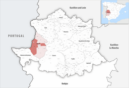
Kommunens läge i provinsen Cáceres | ||
| Webbplats: www.alcantara.es | ||
Alcántara är en ort och kommun i provinsen Cáceres i den autonoma regionen Extremadura i västra Spanien. Orten ligger vid floden Tajo, cirka 52 kilometer nordväst om Cáceres. Kommunen gränsar till Portugal i väster. Kommunen har 1 348 invånare (2023),[2] på en yta av 552,01 km².[1] Franciskanen Pedro de Alcántara föddes i Alcántara.
Referenser
- ^ [a b] ”Nomenclátor Geográfico de Municipios y Entidades de Población” (på spanska). Organismo Autónomo Centro Nacional de Información Geográfica (CNIG). Instituto Geográfico Nacional (IGN). https://centrodedescargas.cnig.es/CentroDescargas/catalogo.do?Serie=CAANE. Läst 20 augusti 2024.
- ^ [a b] ”Cifras oficiales del padrón por municipio (1996–2023)” (på spanska). Instituto Nacional de Estadística (INE). https://www.ine.es/jaxiT3/Tabla.htm?t=29005&L=0. Läst 5 januari 2024.
Externa länkar
 Wikimedia Commons har media som rör Alcántara.
Media som används på denna webbplats
Författare/Upphovsman: Roi González Villa (Vivaelcelta), Licens: CC BY-SA 3.0
Location map of Spain
Equirectangular projection, N/S stretching 130 %. Geographic limits of the map:
- N: 44.4° N
- S: 34.7° N
- W: 9.9° W
- E: 4.8° E
Shiny red button/marker widget. Used to mark the location of something such as a tourist attraction.
Författare/Upphovsman: BetacommandBot, Licens: CC BY-SA 4.0
The flag of Extremadura, an autonomous community of Spain.
Författare/Upphovsman: Alta Falisa, Licens: CC BY-SA 4.0
Because of its nearby bridge (first built early 2nd century) over Rio Tajo, Alcántara had to sustain several armed conflicts : during the Reconquista, the War of Succession of Spain, the War of Independence from the napoléonic régime, and the Carlist Wars.
Its present state (dating to 1859 and due to Engineer Alejandro Millán y Sociats (1824-1889)) is seen here from the left bank's car park.
Författare/Upphovsman: Tschubby, Licens: CC BY-SA 3.0
Gemeinde Alcántara


