Albany County, Wyoming
| Albany County | |
| County | |
| Land | |
|---|---|
| Delstat | |
| Huvudort | Laramie |
| Största stad | Laramie |
| Area | 11 160 km² (2010)[1] |
| - land | 11 069 km² (99%) |
| - vatten | 90,5 km² (1%) |
| Folkmängd | 36 299 (2010)[2] |
| Befolkningstäthet | 3,3 invånare/km² |
| Grundat | 1868 |
| - uppkallat efter | Albany, New York |
| Tidszon | MST (UTC-7) |
| - sommartid | MDT (UTC-6) |
| FIPS-kod | 56001 |
| Geonames | 5816904 |
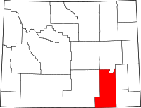
Läge i delstaten Wyoming. | |
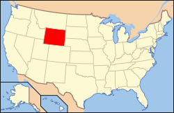
Delstatens läge i USA. | |
Albany County [ˈɔːlbəniː] är ett administrativt område i delstaten Wyoming, USA, med 36 299 invånare. Den administrativa huvudorten (county seat) är universitetsstaden Laramie, där huvuddelen av countyts befolkning bor.
Historia
Nybyggarleden Overland Trail gick genom området i mitten av 1800-talet. Under 1860-talet byggdes den transamerikanska järnvägen genom området, då även det som blev countyts huvudort, staden Laramie, grundades vid järnvägen.
Albany County bildades genom beslut av Dakotaterritoriets legislatur 16 december 1868, genom att avdelas från Laramie County som då tillhörde Dakotaterritoriet. Följande år, 1869, blev countyt del av det då nybildade Wyomingterritoriet när delar av Dakotaterritoriet kom att ingå i Wyomingterritoriet.
Charles D. Bradley som var medlem av territoriallegislaturen lät uppkalla countyt efter sin födelsestats huvudstad, Albany, New York. År 1875 avdelades Crook County och Johnson County från Albany County och 1888 avdelades även Converse County. Countyt kom att behålla sina gränser inom delstaten Wyoming, som bildades 1890. Sedan dess har countyt sina nuvarande gränser, med undantag för mindre gränsjusteringar mot angränsande countyn 1911 och 1955.
Geografi
Enligt United States Census Bureau har countyt en total area på 11 160 km². 11 067 km² av den arean är land och 93 km² är vatten.
Angränsande countyn
- Converse County, Wyoming - nord
- Platte County - öst
- Laramie County, Wyoming - öst
- Larimer County, Colorado - syd
- Jackson County, Colorado - sydväst
- Carbon County - väst
Orter
Invånarantal vid 2010 års folkräkning anges inom parentes.
Större stad (City)
Städer med över 4 000 invånare och kommunalt självstyre:
- Laramie (30 816), huvudort
Småstad (Town)
Städer med under 4 000 invånare och kommunalt självstyre:
- Rock River (245)
Census-designated places
Orter som saknar kommunalt självstyre:
- Albany (55)
- Centennial (270)
- Fox Park (22)
- Woods Landing-Jelm (97)
Övriga befolkade platser
- Binford
- Bosler
- Bosler Junction
- The Buttes
- PhinDeli (tidigare Buford)
- Cooper Lake
- Dale Creek
- Deerwood
- Garrett
- Gramm
- Harmony
- Hatton
- Hermosa
- Hirsing
- Howell
- Keystone
- Little Medicine
- Lookout
- Millbrook
- Mountain Home
- New Jelm
- Red Buttes
- Reed Place
- Squaw Place
- Tie Siding
- Toltec
- Wilcox
- Wyocolo
Spökstäder
Större vägar
 Interstate 80
 U.S. Route 30
 U.S. Route 287
- Wyoming State Route 230
- Wyoming State Route 130
Källor
- ^ ”2010 Census U.S. Gazetteer Files for Counties”. U.S. Census Bureau. Arkiverad från originalet den 5 juli 2012. https://www.webcitation.org/68vYLbou5?url=http://www.census.gov/geo/www/gazetteer/files/Gaz_counties_national.txt. Läst 5 juli 2012.
- ^ ”State & County QuickFacts, Albany County, Wyoming” (på engelska). U.S. Census Bureau. Arkiverad från originalet den 6 juli 2011. https://www.webcitation.org/5zyiBS3r8?url=http://quickfacts.census.gov/qfd/states/56/56001.html. Läst 6 juli 2011.
| ||||||||||||||||||||
| ||||||||||
Media som används på denna webbplats
600 mm × 600 mm (24 in × 24 in) U.S. Highway shield, made to the specifications of the 2004 edition of Standard Highway Signs. (Note that there is a missing "J" label on the left side of the diagram.) Uses the Roadgeek 2005 fonts. (United States law does not permit the copyrighting of typeface designs, and the fonts are meant to be copies of a U.S. Government-produced work anyway.)
This is a locator map showing Albany County in Wyoming. For more information, see Commons:United States county locator maps.
750 mm × 600 mm (30 in × 24 in) U.S. Highway shield, made to the specifications of the 2004 edition of Standard Highway Signs. (Note that there is a missing "J" label on the left side of the diagram.) Uses the Roadgeek 2005 fonts. (United States law does not permit the copyrighting of typeface designs, and the fonts are meant to be copies of a U.S. Government-produced work anyway.)
Författare/Upphovsman: Rick Cummings from Colorado, United States, Licens: CC BY 2.0
Snowy Range — in Albany County, Wyoming.
- 27
Författare/Upphovsman: This version: uploader
Base versions this one is derived from: originally created by en:User:Wapcaplet, Licens: CC BY 2.0
Map of USA with Wyoming highlighted
600 mm by 600 mm (24 in by 24 in) Interstate shield, made to the specifications of the 2004 edition of Standard Highway Signs (sign M1-1). Uses the Roadgeek 2005 fonts. (United States law does not permit the copyrighting of typeface designs, and the fonts are meant to be copies of a U.S. Government-produced work anyway.) Colors are from [1] (Pantone Red 187 and Blue 294), converted to RGB by [2]. The outside border has a width of 1 (1 mm) and a color of black so it shows up; in reality, signs have no outside border.


