Aix-les-Bains
| Aix-les-Bains | ||
| Kommun | ||
 | ||
| ||
| Land | ||
|---|---|---|
| Region | Auvergne-Rhône-Alpes | |
| Departement | ||
| Arrondissement | Chambéry | |
| Kanton | chef-lieu över 3 kantoner | |
| Koordinater | 45°42′N 5°55′Ö / 45.700°N 5.917°Ö | |
| Yta | 12,62 km²[1] | |
| Folkmängd | 31 874 ()[2] | |
| Befolkningstäthet | 2 526 invånare/km² | |
| Borgmästare | Renaud Beretti (2020–) | |
| Tidszon | CET (UTC+1) | |
| - sommartid | CEST (UTC+2) | |
| Postnummer | 73100 | |
| INSEE | 73008 | |
| Geonames | 6452510 | |
| OSM-karta | 74287 | |
 Kommunens läge i regionen Auvergne-Rhône-Alpes i Frankrike | ||
| Webbplats: http://www.aixlesbains.fr | ||


Aix-les-Bains är en kommun och stad i departementet Savoie i östra Frankrike nära Lac du Bourget. År 2021 hade Aix-les-Bains 31 874 invånare.
Aix-les-Bains är en sous-préfecture i departementet Savoie i regionen Auvergne-Rhône-Alpes.
Namnet Aix kommer från latinets Aquae, och staden har varit en kurort sedan antiken, långt innan romarna döpte om staden till Aquae Gratianae till minne av kejsaren Flavius Gratianus Augustus som blev mördad 383 i Lyon i närheten. Staden innehåller också många romerska lämningar.
Flera andra städer som var kända för sina badanläggningar fick även de namn som Aix-en-Provence, Ax-les-Thermes och Aix-la-Chapelle.
Befolkningsutveckling
Antalet invånare i kommunen Aix-les-Bains
 Referens: INSEE[3] |
Galleri
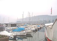 Småbåtshamnen
 Aix-les-Bains vid sekelskiftet 1900
 Aix-les-Bains vid sekelskiftet 2000
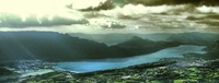 Bourgetsjön (Lac du Bourget) från Nivolet (1547 m).
 Flygplatsen

Se även
Källor
- ^ Répertoire géographique des communes, Institut national de l'information géographique et forestière, läst: 26 oktober 2015.[källa från Wikidata]
- ^ Populations légales 2021, Institut National de la Statistique et des Études Économiques, 28 december 2023.[källa från Wikidata]
- ^ Chiffres clés - Évolution et structure de la population hämtat från the Wayback Machine (arkiverat 4 maj 2012).
Externa länkar
- Aix-les-Bains officiella hemsida
 Wikimedia Commons har media som rör Aix-les-Bains.
Media som används på denna webbplats

Författare/Upphovsman: Eric Gaba (Sting - fr:Sting), Licens: CC BY-SA 4.0
Blank physical map of metropolitan France for geo-location purpose.
Scale : 1:14 816 000 (accuracy : about 3,7 km) for the bathymetry. More maps of France, view → Commons Atlas of France.

Shiny red button/marker widget. Used to mark the location of something such as a tourist attraction.

Författare/Upphovsman: Wikialine, Licens: CC BY-SA 3.0
Le centre ville de la commune d'Aix-les-Bains en France dans le département de la Savoie.


Författare/Upphovsman: Fabsss, Licens: CC BY-SA 3.0
Terminal of Chambéry-Savoie Airport (CMF)
Författare/Upphovsman: Michiel1972, Licens: CC BY-SA 3.0
Population - Municipality code 73008.svg
Population Census 1962-2008
Författare/Upphovsman: Xtrasystole, Licens: CC BY-SA 3.0
A panoramic view of Lake Bourget (lac du Bourget) in the French Alps, as seen from the Nivolet promontory (1,547m/5,076ft). The city of Aix-les-Bains can be seen on the right hand side of the picture. The Le Bourget/Chambéry airport is visible on the left side of the photograph, at the southern end of the lake. Date of photo: 17 August 2007.
Författare/Upphovsman: AlNo (discuter/talk/hablar/falar), Licens: CC BY 2.5
Church of Aix-les-Bains, France.

Författare/Upphovsman:
|
Map data (c) OpenStreetMap contributors, CC-BY-SA _French_municipality_map.svg) • Shape files infrastructure: railway, highways, water: all originally by OpenStreetMap contributors. Status december 2011 *note: shown commune boundaries are from OSM dump May 2012; at that time about 90% complete |
Map of French municipality

Författare/Upphovsman: Wikialine, Licens: CC BY-SA 3.0
Le port de la ville d'Aix-les-Bains en France dans le département de la Savoie.
Författare/Upphovsman: J.P. FRANCOZ, Licens: FAL
Aix-les-Bains et le lac du Bourget. Plus grand lac naturel de France.

Thermal Baths Place, Aix-les-Bains, France.