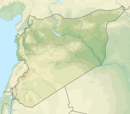
Afrin
| Afrin | |
| عفرين Efrîn | |
| Stad | |
| Land | |
|---|---|
| Indelning | Afrin (de facto) |
| Höjdläge | 270 m ö.h. |
| Koordinater | 36°30′30″N 36°52′9″Ö / 36.50833°N 36.86917°Ö |
| Folkmängd | 36 562 (2004)[1] |
| Demokratisk konfederalism | Fria Syriska Armén |
| Tidszon | Östeuropeisk tid (EET) |
| Geonames | 174186 |
| Webbplats: Officiell webbplats | |

Afrin är en stad i distrikt Afrin i norra Syrien. År 2005 bodde enligt folkräkningen 172.095 personer i distriktet Afrin varav ca 36.500 i huvudorten Afrin.
Historik
Syriska inbördeskriget
Afrin Canton deklarerade sig som en de facto autonom region den 29 januari 2014,[2][3]
Källor
- ^ General Census of Population and Housing 2004. Statistiska centralbyrån i Syrien (CBS). Provinsen Aleppo. (arabiska)
- ^ ”Democratic autonomy has declared in Afrin canton in Rojava”. Mednuce. 29 januari 2014. Arkiverad från originalet den 6 juli 2018. https://web.archive.org/web/20180706022020/http://mednuce.com/en//haber/2344/democratic-autonomy-has-declared-in-afrin-canton-in-rojava.html. Läst 23 oktober 2014.
- ^ ”After Cizîre, Kobanê Canton has been declared”. Firat News. http://supportkurds.org/news/monday-27-january-2013/. Läst 23 oktober 2014.
Media som används på denna webbplats
Shiny red button/marker widget. Used to mark the location of something such as a tourist attraction.
Författare/Upphovsman: Mouradi, Licens: CC BY-SA 3.0
The current situation in Afrin Area as of 22.06.2013.
Yellow:YPG
Green: FSA/rebels
Red: Loyalists
Grey: Urban areas
The red streches are roads
The blue strech is a river.
Grey: Urban areas
Författare/Upphovsman:
- Syria_location_map.svg: NordNordWest
- Syria_physical_map.svg: Urutseg
- derivative work: NordNordWest
Physical location map of Syria. De facto situation.
Flag of Syria. Originally flag of the Syria Revolution (from 2011), de facto flag of Syria beginning December 2024, official beginning March 2025.


