Ada, Ohio
| Ada | |
| Bykommun (village) | |
Presbyteriansk kyrka i Ada | |
| Land | |
|---|---|
| Delstat | |
| County | Hardin County |
| Höjdläge | 292 m ö.h. |
| Koordinater | 40°46′7″N 83°49′20″V / 40.76861°N 83.82222°V |
| Area | 5,53 km² (2020)[1] |
| Folkmängd | 5 334 (2020)[2][3] |
| Befolkningstäthet | 965 invånare/km² |
| Grundad | 1853 |
| Tidszon | EST (UTC-5) |
| - sommartid | EDT (UTC-4) |
| ZIP-kod | 45810 |
| Riktnummer | 419 |
| GNIS-kod | 1064295 |
| Geonames | 5145374 |
Ortens läge i delstaten | |
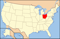
Ohios läge i USA | |
| Wikimedia Commons: Ada, Ohio | |
| Webbplats: https://www.adaoh.org/ | |
| Redigera Wikidata | |

Ada är en stad (village) i Hardin County i delstaten Ohio i USA. Staden hade 5 334 invånare, på en yta av 5,53 km² (2020).[4][5]
I Ada ligger Ohio Northern University.
Referenser
- ^ Gazetteer Files – 2020 (på engelska), United States Census Bureau, läs online, läst: 11 november 2021.[källa från Wikidata]
- ^ Explore Census Data – Ada village, Ohio (på engelska), United States Census Bureau, läs online, läst: 11 november 2021.[källa från Wikidata]
- ^ United States Census Bureau (red.), USA:s folkräkning 2020, läs online, läst: 1 januari 2022.[källa från Wikidata]
- ^ ”Explore Census Data – Ada village, Ohio” (på engelska). United States Census Bureau. https://data.census.gov/cedsci/profile?g=1600000US3900198. Läst 11 november 2021.
- ^ ”Gazetteer Files – 2020” (på engelska). United States Census Bureau. https://www.census.gov/geographies/reference-files/time-series/geo/gazetteer-files.2020.html. Läst 11 november 2021.
Externa länkar
 Wikimedia Commons har media som rör Ada.
- Officiell webbplats
Media som används på denna webbplats
Shiny red button/marker widget. Used to mark the location of something such as a tourist attraction.
Författare/Upphovsman: Alexrk2, Licens: CC BY 3.0
Den här Det karta skapades med GeoTools.
Författare/Upphovsman: This version: uploader
Base versions this one is derived from: originally created by en:User:Wapcaplet, Licens: CC BY 2.0
Map of USA with Ohio highlighted
Författare/Upphovsman: Ruhrfisch and Nyttend, Licens: CC BY-SA 3.0
Map of the municipal and township boundaries of Hardin County, Ohio, United States, as of the 2000 census, with the location of the village of Ada highlighted. Township borders are shown only in unincorporated areas in order to differentiate incorporated and unincorporated areas more clearly.
Front and northern side of the First Presbyterian Church of Ada, Ohio, United States, located at 201 S. Main Street (State Route 235). It was built in 1890.


