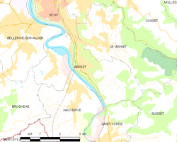
Abrest
| Abrest | ||
| Kommun | ||
Stadshuset i Abrest | ||
| ||
| Land | ||
|---|---|---|
| Region | Auvergne-Rhône-Alpes | |
| Departement | ||
| Arrondissement | Vichy | |
| Kanton | Vichy-2 | |
| Koordinater | 46°05′53″N 03°26′42″Ö / 46.09806°N 3.44500°Ö | |
| Högsta punkt | ||
| - höjdläge | 434 m ö.h. | |
| Lägsta punkt | ||
| - höjdläge | 251 m ö.h. | |
| Yta | 10,46 km²[1] | |
| Folkmängd | 2 919 ()[2] | |
| Befolkningstäthet | 279 invånare/km² | |
| Tidszon | CET (UTC+1) | |
| - sommartid | CEST (UTC+2) | |
| Postnummer | 03200 | |
| INSEE | 03001 | |
| Geonames | 3038735 | |
| OSM-karta | 116515 | |
 Kommunens läge i regionen Auvergne-Rhône-Alpes i Frankrike | ||
| Webbplats: https://www.abrest.fr/ | ||

Abrest är en kommun i departementet Allier i regionen Auvergne-Rhône-Alpes i de centrala delarna av Frankrike. Kommunen ligger i kantonen Vichy-2 som ligger i arrondissementet Vichy. År 2017 hade Abrest 2 931 invånare.
Befolkningsutveckling
Antalet invånare i kommunen Abrest
 Referens: INSEE[3] |
Se även
Källor
- ^ Répertoire géographique des communes, Institut national de l'information géographique et forestière, läst: 26 oktober 2015, licens: öppen licens.[källa från Wikidata]
- ^ Populations légales 2021, Institut National de la Statistique et des Études Économiques, 28 december 2023.[källa från Wikidata]
- ^ Chiffres clés - Évolution et structure de la population hämtat från the Wayback Machine (arkiverat 4 maj 2012).
Externa länkar
 Wikimedia Commons har media som rör Abrest.
|
Media som används på denna webbplats
Författare/Upphovsman: Wiki-MG**** @@@-fr Accueil fr:Accueil 10:21, 12 January 2007 (UTC), Licens: CC BY-SA 3.0
Arms of the department of Allie, France: Azure semé-de-lis or, a bend gules
Författare/Upphovsman: Eric Gaba (Sting - fr:Sting), Licens: CC BY-SA 4.0
Blank physical map of metropolitan France for geo-location purpose.
Scale : 1:14 816 000 (accuracy : about 3,7 km) for the bathymetry. More maps of France, view → Commons Atlas of France.
Shiny red button/marker widget. Used to mark the location of something such as a tourist attraction.
Författare/Upphovsman: Kaiser 16, Licens: CC BY-SA 3.0
D’argent à la bande d’azur évidée en forme du chiffre 8; à l’inscription « ABREST » en lettres capitales de gueules, les lettres décroissantes par le bas des flancs vers le centre, l’inscription accostée de deux tours couvertes d’or ajourée de sable, le tout enfermé dans une bordure réduite de pourpre
Författare/Upphovsman: Michiel1972, Licens: CC BY-SA 3.0
Population - Municipality code 03001.svg
Population Census 1962-2008Författare/Upphovsman: Tabl-trai, Licens: CC BY-SA 3.0
Townhall of Abrest, Allier, Auvergne, France.
Författare/Upphovsman:
|
Map data (c) OpenStreetMap contributors, CC-BY-SA  • Shape files infrastructure: railway, highways, water: all originally by OpenStreetMap contributors. Status december 2011 *note: shown commune boundaries are from OSM dump May 2012; at that time about 90% complete |
Map commune FR insee code 03001.png


