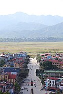
Điện Biên Phủ
| Điện Biên Phủ | |
| Dien Bien Phu | |
| Stad | |
Điện Biên Phủ, 2012. | |
| Land | |
|---|---|
| Provins | Điện Biên |
| Koordinater | 21°23′09″N 103°01′21″Ö / 21.38583°N 103.02250°Ö |
| Folkmängd | |
| - centralort | 55 251 (1 april 2019)[1] |
| - stad | 58 519 (1 april 2019)[1] |
| Geonames | 1583477 |
Điện Biên Phủs läge i Vietnam. | |
Điện Biên Phủ är en stad i nordvästra Vietnam och är huvudstad i provinsen Điện Biên. Folkmängden i centralorten uppgick till cirka 55 000 invånare vid folkräkningen 2019. Staden är främst känd för slaget vid Dien Bien Phu den 6 maj 1954, då Vietminhs styrkor efter 57 dagars belägring lyckades besegra den franska garnisonen.
Källor
Media som används på denna webbplats
Shiny red button/marker widget. Used to mark the location of something such as a tourist attraction.
Författare/Upphovsman: Uwe Dedering, Licens: CC BY-SA 3.0
Location map of Vietnam.
Equirectangular projection. Strechted by 104.0%. Geographic limits of the map:
* N: 24.0° N
* S: 8.0° N
* W: 101.8° E
* E: 110.3° E
Made with Natural Earth. Free vector and raster map data @ naturalearthdata.com.


