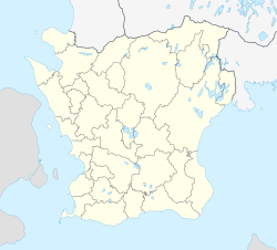
Östra Kärrstorp
| Östra Kärrstorp | |
| Småort | |
| Land | |
|---|---|
| Landskap | Skåne |
| Län | Skåne län |
| Kommun | Sjöbo kommun |
| Koordinater | 55°42′42″N 13°43′43″Ö / 55.71167°N 13.72861°Ö |
| Tidszon | CET (UTC+1) |
| - sommartid | CEST (UTC+2) |
Östra Kärrstorps läge i Skåne län | |
Östra Kärrstorp är kyrkbyn i Östra Kärrstorps socken i Sjöbo kommun i Skåne belägen norr om Sjöbo och sydost om Bjärsjölagård. I byn fanns en hållplats längs före detta järnvägen Ystad-Eslöv.
Här ligger Östra Kärrstorps kyrka.
Media som används på denna webbplats
Författare/Upphovsman: Erik Frohne, Licens: CC BY 3.0
Location map of Scania (Skåne) in Sweden
Equirectangular projection, N/S stretching 179 %. Geographic limits of the map:
- N: 56° 37' N
- S: 55° 12' N
- W: 12° 12' E
- E: 15° 00' E
Shiny red button/marker widget. Used to mark the location of something such as a tourist attraction.
Författare/Upphovsman: Väsk, Licens: CC BY-SA 3.0
Östra Kärrstorps kyrka, Sjöbo kommun, Skåne, Lunds stift, Sverige.


