Östanvik, Rättviks kommun
| Östanvik | |
| småort | |
| Land | |
|---|---|
| Landskap | Dalarna |
| Län | Dalarnas län |
| Kommun | Rättviks kommun |
| Distrikt | Ore distrikt |
| Koordinater | 61°9′43″N 15°12′58″Ö / 61.16194°N 15.21611°Ö |
| Area | 1,37 km² (2020)[1] |
| Folkmängd | 103 (2020)[1] |
| Befolkningstäthet | 75 inv./km² |
| Tidszon | CET (UTC+1) |
| - sommartid | CEST (UTC+2) |
| Tätortskod | TX698[2] |
| Småortskod | S6991[3] |
| Beb.områdeskod | 2031TB113 (1960–1980)[4] 2031SB131 (1995–)[4] |
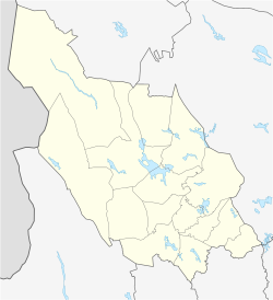
Ortens läge i Dalarnas län | |
| SCB:s bebyggelseområdesavgränsning Redigera Wikidata | |
Östanvik är en småort i Ore socken i Rättviks kommun, Dalarna.
Befolkningsutveckling
| Befolkningsutvecklingen i Östanvik 1960–2015[5] | ||||
|---|---|---|---|---|
| År | Folkmängd | Areal (ha) | ||
| 1960 | 352 | |||
| 1965 | 306 | |||
| 1970 | 267 | |||
| 1975 | 208 | |||
| 1995 | 121 | 140# | ||
| 2000 | 128 | 139# | ||
| 2005 | 95 | 139# | ||
| 2010 | 111 | 132# | ||
| 2015 | 103 | 136# | ||
Anm.: Upphörde som tätort 1980. # Som småort. | ||||
Noter
- ^ [a b] Statistiska småorter 2020, befolkning, landareal, befolkningstäthet per småort, Statistiska centralbyrån, 31 mars 2022, läs online.[källa från Wikidata]
- ^ Befolkning i tätorter 1960-2010, Statistiska centralbyrån, läs online, läst: 13 februari 2014.[källa från Wikidata]
- ^ Småorternas landareal, folkmängd och invånare per km² 2005 och 2010, korrigerad 2012-10-15, Statistiska centralbyrån, 15 oktober 2012, läs online, läst: 9 juli 2016.[källa från Wikidata]
- ^ [a b] Kodnyckel för SCB:s statistiska tätorter och småorter - Koppling mellan gammalt och nytt kodsystem, Statistiska centralbyrån, 11 november 2021, läs online.[källa från Wikidata]
- ^ ”Statistiska centralbyrån - Folkmängd i tätorter 1960-2005”. Arkiverad från originalet den 23 juni 2011. https://www.webcitation.org/5zewoamwt?url=http://www.scb.se/statistik/MI/MI0810/2005A01x/MI0810_2005A01x_SM_MI38SM0703.pdf. Läst 8 februari 2012.
| ||||||||||||||||
Media som används på denna webbplats
Författare/Upphovsman: Erik Frohne, Licens: CC BY 3.0
Location map of Dalarna County in Sweden
Equirectangular projection, N/S stretching 206 %. Geographic limits of the map:
- N: 62.30° N
- S: 59.70° N
- W: 12.00° E
- E: 16.90° E
Shiny red button/marker widget. Used to mark the location of something such as a tourist attraction.


