Île le Boulanger
| Île le Boulanger | |
| Îlot Boulanger, Le Boulanger | |
| Ö | |
| Land | |
|---|---|
| Koordinater | 17°57′20″N 62°52′23″V / 17.95569°N 62.87309°V |
| Area | 0,3 km² |
| Tidszon | AST (UTC-4) |
| Geonames | 3579636 |
(c) Eric Gaba, Wikimedia Commons user Sting, CC BY-SA 3.0 | |
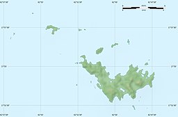
Île le Boulanger är en obebodd ö i Saint-Barthélemy (Frankrike). Den ligger nordväst om huvudön, 7 km norr om huvudstaden Gustavia.
Media som används på denna webbplats
(c) Eric Gaba, Wikimedia Commons user Sting, CC BY-SA 3.0
Blank physical map of the overseas collectivity of Saint Barthélemy, France, for geo-location purpose.
Shiny red button/marker widget. Used to mark the location of something such as a tourist attraction.


