Île-d'Aix
| Île-d'Aix | ||
| Kommun | ||
 Vy över ön | ||
| ||
| Land | ||
|---|---|---|
| Region | Nouvelle-Aquitaine | |
| Departement | ||
| Arrondissement | Rochefort | |
| Kanton | Châtelaillon-Plage | |
| Koordinater | 46°0′44″N 1°10′26″V / 46.01222°N 1.17389°V | |
| Yta | 1,19 km²[1] | |
| Folkmängd | 196 ()[2] | |
| Befolkningstäthet | 165 invånare/km² | |
| Tidszon | CET (UTC+1) | |
| - sommartid | CEST (UTC+2) | |
| Postnummer | 17123 | |
| INSEE | 17004 | |
| Geonames | 6614243 | |
| OSM-karta | 113454 | |
 Kommunens läge i regionen Nouvelle-Aquitaine i Frankrike | ||
| Webbplats: http://www.iledaix.fr | ||


Île-d'Aix är en kommun i departementet Charente-Maritime i regionen Nouvelle-Aquitaine i sydvästra Frankrike. Kommunen ligger i kantonen Châtelaillon-Plage som ligger i arrondissementet Rochefort. År 2022 hade Île-d'Aix 196 invånare.
Befolkningsutveckling
| Befolkningsutvecklingen i Île-d'Aix 1968–2021[3] | ||||
|---|---|---|---|---|
| År | Folkmängd | |||
| 1968 | 207 | |||
| 1975 | 207 | |||
| 1982 | 173 | |||
| 1990 | 199 | |||
| 1999 | 186 | |||
| 2007 | 219 | |||
| 2015 | 249 | |||
| 2021 | 207 | |||
Bildgalleri


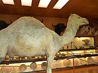 Afrikamuseet
 Napoleon II-museet
Se även
Källor
- ^ Répertoire géographique des communes, Institut national de l'information géographique et forestière, läst: 26 oktober 2015.[källa från Wikidata]
- ^ Populations légales 2022, Institut National de la Statistique et des Études Économiques, 19 december 2024.[källa från Wikidata]
- ^ ”Historique des populations légales – Recensements de la population 1968–2021” (på franska). www.insee.fr. Institut national de la statistique et des études économiques (INSEE). 28 december 2023. https://www.insee.fr/fr/statistiques/2522602. Läst 22 augusti 2024.
Media som används på denna webbplats

Författare/Upphovsman: Eric Gaba (Sting - fr:Sting), Licens: CC BY-SA 4.0
Blank physical map of metropolitan France for geo-location purpose.
Scale : 1:14 816 000 (accuracy : about 3,7 km) for the bathymetry. More maps of France, view → Commons Atlas of France.

Shiny red button/marker widget. Used to mark the location of something such as a tourist attraction.
Författare/Upphovsman:
|
Map data (c) OpenStreetMap contributors, CC-BY-SA _French_municipality_map.svg) • Shape files infrastructure: railway, highways, water: all originally by OpenStreetMap contributors. Status december 2011 *note: shown commune boundaries are from OSM dump May 2012; at that time about 90% complete |
Map commune FR insee code 17004.png
.JPG)

Författare/Upphovsman: The original uploader was Pep.per på franska Wikipedia., Licens: CC BY-SA 1.0
Les Phares de l'île d'Aix - Charente-Maritime
Photo issue de ma banque d'imges personnelle : http://www.imagesdile.com


(c) Pep.per på franska Wikipedia, CC BY-SA 3.0
Fort Boyard east side, Charente-Maritime, France

Författare/Upphovsman: The original uploader was Pep.per på franska Wikipedia., Licens: CC BY-SA 1.0
Fossé du fort de l'île d'Aix
Photo issue de ma banque d'images personnelle
Författare/Upphovsman: Pierre Mairé, Licens: CC BY-SA 3.0
The Island of Aix seen from the air from the south-west at dusk. Aix is located at the mouth of the Charente River on the west coast of France.

Författare/Upphovsman: Ji-Elle, Licens: CC BY-SA 3.0
Camel allegedly mounted by General Bonaparte during his campaign in Egypt (Musée africain, Ile d'Aix)
