Étables-sur-Mer
| Étables-sur-Mer | ||
| Kommun | ||
 | ||
| ||
| Land | ||
|---|---|---|
| Region | ||
| Departement | ||
| Arrondissement | Saint-Brieuc | |
| Kanton | Étables-sur-Mer | |
| Koordinater | 48°37′N 2°50′V / 48.617°N 2.833°V | |
| Yta | 9,38 km²[1] | |
| Folkmängd | 3 180 ()[2] | |
| Befolkningstäthet | 339 invånare/km² | |
| Tidszon | CET (UTC+1) | |
| - sommartid | CEST (UTC+2) | |
| Postnummer | 22680 | |
| INSEE | 22055 | |
| Geonames | 3019480 | |
| OSM-karta | 342459 | |
 Kommunens läge i regionen Bretagne i Frankrike | ||

Étables-sur-Mer är en kommun i departementet Côtes-d'Armor i regionen Bretagne i nordvästra Frankrike. Kommunen ligger i kantonen Étables-sur-Mer som tillhör arrondissementet Saint-Brieuc. År 2018 hade Étables-sur-Mer 3 180 invånare.
Befolkningsutveckling
Antalet invånare i kommunen Étables-sur-Mer
Referens:INSEE[3]
Bilder
 Plage des Godelins.
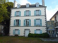 Villa Ker Ruellan.

Se även
Källor
- ^ Répertoire géographique des communes, Institut national de l'information géographique et forestière, läst: 26 oktober 2015.[källa från Wikidata]
- ^ Populations légales 2018, Institut National de la Statistique et des Études Économiques, 28 december 2020.[källa från Wikidata]
- ^ Chiffres clés - Évolution et structure de la population Arkiverad 5 juli 2012 hämtat från the Wayback Machine.
Media som används på denna webbplats


Författare/Upphovsman: Eric Gaba (Sting - fr:Sting), Licens: CC BY-SA 4.0
Blank physical map of metropolitan France for geo-location purpose.
Scale : 1:14 816 000 (accuracy : about 3,7 km) for the bathymetry. More maps of France, view → Commons Atlas of France.

Shiny red button/marker widget. Used to mark the location of something such as a tourist attraction.
Författare/Upphovsman:
|
Map data (c) OpenStreetMap contributors, CC-BY-SA _French_municipality_map.svg) • Shape files infrastructure: railway, highways, water: all originally by OpenStreetMap contributors. Status december 2011 *note: shown commune boundaries are from OSM dump May 2012; at that time about 90% complete |
Map commune FR insee code 22055.png
Plage du Moulin à Étables sur Mer. Rocher de la Fille juste en face, avec la balise du rocher le Four qui se trouve immédiatement derrière. Au fond à gauche, les roches de Saint-Quai (appellation maritime).
.svg)
Författare/Upphovsman: unknown, Licens: CC BY-SA 3.0

Författare/Upphovsman: Spendeau, Licens: CC BY-SA 3.0
La villa Ker Ruellan, centre de vacances et centre social communal