Épernay
| Épernay | ||
| Kommun | ||
 | ||
| ||
| Land | ||
|---|---|---|
| Region | Grand Est | |
| Departement | ||
| Arrondissement | Épernay (chef-lieu) | |
| Kanton | chef-lieu för 2 kantoner | |
| Koordinater | 49°3′N 3°57′Ö / 49.050°N 3.950°Ö | |
| Yta | 22,69 km²[1] | |
| Folkmängd | 22 001 ()[2] | |
| Befolkningstäthet | 970 invånare/km² | |
| Tidszon | CET (UTC+1) | |
| - sommartid | CEST (UTC+2) | |
| Postnummer | 51200 | |
| INSEE | 51230 | |
| Geonames | 6435803 | |
| OSM-karta | 417327 | |
 Kommunens läge i regionen Grand Est i Frankrike | ||
| Webbplats: http://www.epernay.fr/ | ||


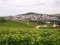
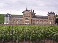
Épernay är en stad och kommun i regionen Grand Est (tidigare regionen Champagne-Ardenne) i nordöstra Frankrike, 140 km öster om Paris, med 22 001 invånare (2021). I Épernay ligger några av de största champagnemärkena såsom Moët & Chandon, Pol Roger och Eugène Mercier. De större märkena ligger samlade på den stora gatan Avenue de Champagne.
Sevärt i Épernay är 'des caves de champagne', de tunnlar under marken där champagneflaskorna lagras. Under Avenue de Champagne ligger cirka 300 miljoner flaskor av olika märken.
Befolkningsutveckling
Antalet invånare i kommunen Épernay
 Referens: INSEE[3] |
Galleri


 Fort Chabrol

Se även
Källor
- ^ Répertoire géographique des communes, Institut national de l'information géographique et forestière, läst: 26 oktober 2015.[källa från Wikidata]
- ^ Populations légales 2021, Institut National de la Statistique et des Études Économiques, 28 december 2023.[källa från Wikidata]
- ^ Chiffres clés - Évolution et structure de la population hämtat från the Wayback Machine (arkiverat 4 maj 2012).
Externa länkar
- Officiell webbplats (franska, engelska)
 Wikimedia Commons har media som rör Épernay.
Media som används på denna webbplats

Författare/Upphovsman: Eric Gaba (Sting - fr:Sting), Licens: CC BY-SA 4.0
Blank physical map of metropolitan France for geo-location purpose.
Scale : 1:14 816 000 (accuracy : about 3,7 km) for the bathymetry. More maps of France, view → Commons Atlas of France.

Shiny red button/marker widget. Used to mark the location of something such as a tourist attraction.

Quartier du Mont Bernon, vue depuis le mont homonyme

Vue générale d'Épernay depuis le mont homonyme

Vue générale depuis l'avenue de France-Comté - Épernay (Marne, Champagne-Ardenne, France).
Författare/Upphovsman: Michiel1972, Licens: CC BY-SA 3.0
Population - Municipality code 51230.svg
Population Census 1962-2008


Épernay (Marne, France) : hôtel de ville, construit vers 1858. Vue prise depuis l'avenue de Champagne.
Palais de justice - Épernay

Épernay - vue générale depuis le chemin de ceinture

Fort Chabrol - Épernay
Författare/Upphovsman:
|
Map data (c) OpenStreetMap contributors, CC-BY-SA _French_municipality_map.svg) • Shape files infrastructure: railway, highways, water: all originally by OpenStreetMap contributors. Status december 2011 *note: shown commune boundaries are from OSM dump May 2012; at that time about 90% complete |
Map commune FR insee code 51230.png