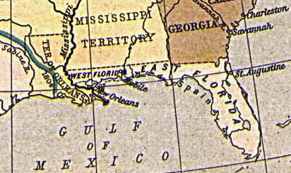
East and West Florida 1810
Författare/Upphovsman:
Kreditera:
From "The Historical Atlas" by William R. Shepherd, 1923. http://www.lib.utexas.edu/maps/historical/shepherd/us_expansion_shepherd.jpg
Kort länk:
Källa:
Upplösning:
412 x 245 Pixel (44916 Bytes)
Beskrivning:
Map of East and West Florida in 1810, from the Perry-Castañeda Map Collection [1]. The boundary between the two provinces is incorrect; it was at the Apalachicola River, not the Perdido River (as shown here).
Licens:
Public domain
Mer information om licensen för bilden finns här. Senaste uppdateringen: Mon, 01 Apr 2024 08:20:21 GMT