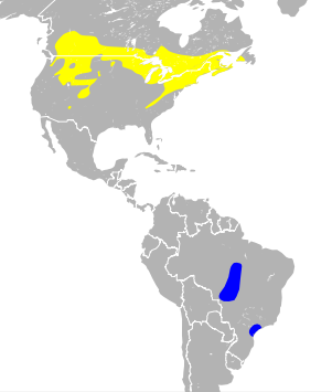
Catharus fuscescens map
Författare/Upphovsman:
Tillskrivning:
Bilden är taggad "Attribution Required" men ingen tillskrivningsinformation lämnades. Attributionsparametern utelämnades troligen när MediaWiki-mallen användes för CC-BY-licenserna. Författare och upphovsmän hittar ett exempel för korrekt användning av mallarna här.
Kreditera:
- range data: Veery Species Range on IUCN Ridgely et al. and BirdLife International (2012) Digital Distribution Maps of the Birds of the Western Hemisphere, version 5.0 . In BirdLife International and NatureServe (2012) Bird species distribution maps of the world. 2012. Catharus fuscescens. In: IUCN 2013. IUCN Red List of Threatened Species. Version 2013.1. http://www.iucnredlist.org. Downloaded on 10 Nov 2013.
- background data: TM_WORLD_BORDERS-0.1 Provided by Bjorn Sandvik, thematicmapping.org
- background data: Made with Natural Earth. Free vector and raster map data @ naturalearthdata.com.
Kort länk:
Källa:
Upplösning:
301 x 354 Pixel (2223497 Bytes)
Beskrivning:
Licens:
Licensvillkor:
Creative Commons Attribution-Share Alike 3.0
Mer information om licensen för bilden finns här. Senaste uppdateringen: Thu, 18 Jan 2024 01:08:46 GMT
