Balkans925
Författare/Upphovsman:
Kreditera:
Made by Hxseek using the following sources:
- Map from: en:File:Roman Empire 125.svg by ArdadN
- Info from:
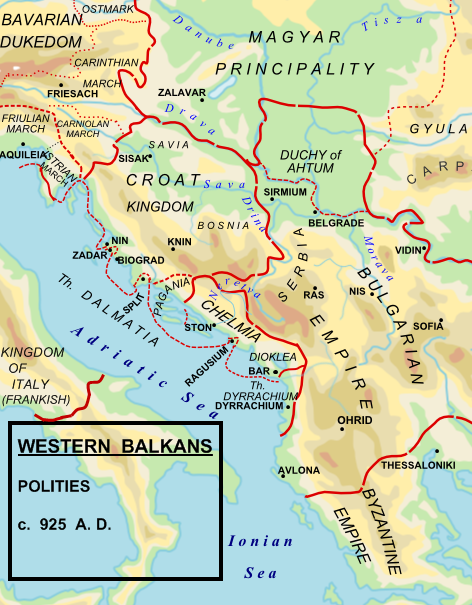
- (1) The Early Medieval Balkans. A Critical Survey from the Sixth to the Late Twelfth Century. J V A Fine, Jr. Pg 262:
- To the south of the Drava, he (King Tomislav)held what we think of modern Croatia, Slavonia, northern and western Bosnia, and the territory along the Dalmatian coast to the mouth of the Cetina river (excluding scattered Byzantine towns)
- (2) The Balkans. From Constantinople to Communism. D P Hupchik. Map 3, depicts Croatia to extend approximately to the Drina river.
- (3) Shepherds Historical Atlas.
Kort länk:
Källa:
Upplösning:
472 x 605 Pixel (230158 Bytes)
Beskrivning:
Political map of the western Balkan in 925 AD.
Licens:
Public domain
Licenskommentaren:
| Detta verk har gjorts tillgänglig som public domain av dess skapare, Hxseek. Detta gäller globalt. I vissa länder kan detta inte vara juridiskt möjligt; i så fall: Hxseek ger envar rätten att använda detta verk för alla ändamål, utan några villkor, förutom villkor som lagen ställer. |
Mer information om licensen för bilden finns här. Senaste uppdateringen: Tue, 24 Sep 2024 05:58:02 GMT