WW2-Holocaust-ROstland
Författare/Upphovsman:
Kreditera:
Kort länk:
Källa:
Upplösning:
442 x 418 Pixel (148010 Bytes)
Beskrivning:
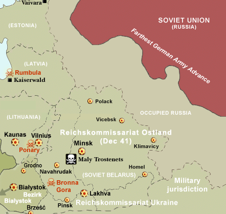
Map of the Holocaust in Reichskommissariat Ostland (Belarus and the Baltic States) during World War II, 1939-1945.
This map shows all extermination camps (or death camps), most major concentration camps, labor camps, prison camps, ghettos, major deportation routes and major massacre sites.
Notes:
1. Extermination camps were dedicated death camps, but all camps and ghettos took a toll of many, many lives.
2. Concentration camps include labor camps, prison camps & transit camps.
3. Not all camps & ghettos are shown.
4. Borders are at the height of Axis domination (1942).
5. Some regions have German designations (e.g. "Ostland"), with the present country name denoted in uppercase letters in parenthesis below the German designation (e.g. "(AUSTRIA)").
6. Present (2007) borders are dotted.
Licens:
Licenskommentaren:
CC, see below. The map is completely unrestricted for any Wikipedia/Wikimedia project.
Licensvillkor:
Creative Commons Attribution 3.0
Mer information om licensen för bilden finns här. Senaste uppdateringen: Sat, 10 Aug 2024 20:21:22 GMT